
A Review to do Fishermen Boat Automation with Artificial Intelligence for Sustainable Fishing Experience Ensuring Safety, Security, Navigation and Sharing Information for Omani Fishermen

Abstract
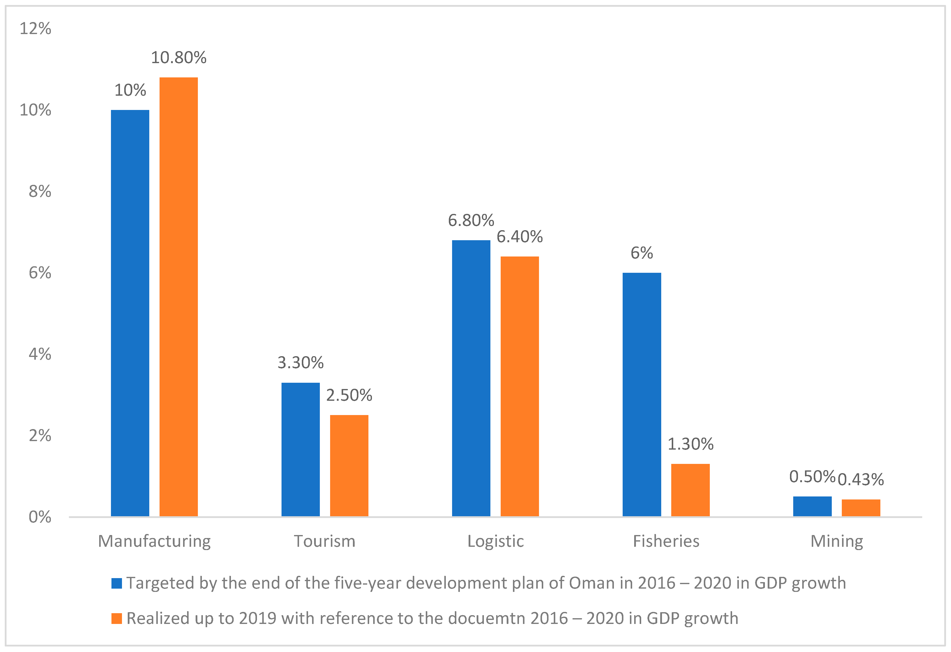
:1. Introduction
- One of the major problems faced is crossing the border area without any intention or due to misguidance;
- Attack by pirates is unknown leading to life loss and injuries;
- Unknown environmental conditions;
- Unknown wind speed which leads to facing unknown storms around the ship;
- Oil spills lead to fire safety issues;
- Illegal fishing is affecting the economic growth of the country and the overall growth of the fishing sector.
2. Review of Illegal Fishing, Maritime Surveillance, and Environmental Monitoring
3. Review of Sea Border Tracking and Automatic Boat Detection Using AI
4. Review Oil Spill Issues and Its Impact on Fishing Inside the Sea
- Service unit;
- Operational storage unit;
- Knowledge discovery unit;
- Notification unit;
- Graphical user interface;
- Environmental decision support system unit.
- Space borne SAR imaging and analysis;
- Ground-based monitoring technology;
- Hyper spectral image and analysis;
- Electronic nodes for hydrocarbon and oil spill detection;
- Underwater monitoring technologies.
- Proactive management of the available resources;
- The provision of services for notification and alerting.
5. Review of Pirates Attack and Its Impact on Fishing Inside the Sea
- To be committed on the high seas.
- To involve violence.
- For the pirate ship to be civil.
- For the attack to be committed for private ends.
6. Possible Solution to Obtain a Better Fishing Experience for Omani Fishermen
- 360 Degree Monitoring;
- Live Location Tracking;
- Radius Monitoring;
- Environmental Monitoring;
- Wind Speed Monitoring;
- Data Monitoring;
- Control Device for Wireless Control and Monitoring;
- Web Application;
- Mobile Application;
- Notification.
- To provide safety, security, and documentation resources to Omani fishermen.
- To avoid sea border crossing by Omani fishermen and also to identify the entry in the Oman Sea zone by neighboring countries’ fishermen.
- To navigate the boat, the navigation information will be shared with the control room, and two-way communication between fishermen and the control room.
- To identify the pirate boats, pirate attacks, and disturbances by external sources.
- To avoid illegal fishing.
- To monitor and prepare documentation resources of the parameters such as temperature, humidity, and pressure with specific time periods.
- To identify fires using smoke sensors and oil spills using chemical sensors and to give alarm warnings to the fishermen immediately.
- To identify the distance of other boats or external objects from the fishermen’s boat in the sea using image-processing techniques, artificial intelligence, and machine learning.
- To develop a battery monitoring which is mandatory to work all of the above systems and information storage.
- To implement modern technologies, such as artificial intelligence, machine learning, cloud storage, networking, etc., in the fishery sector.
- To give effective information sharing between the control room, fishermen, and fishermen’s family members.
- The Section 7 will discuss the materials and methods involved in boat automation.
7. Materials, Methods, System Design, and Control
7.1. 360 Degree Monitoring
- One of the major problems faced by the ships is unknown objects and ships found around the ships.
- Certain situations are unrecognized by the people due to the lack of human ability to have continuous monitoring around the ship and misconceptions about the ships found around it.
- To solve this problem, a 360-degree camera module can be interfaced with the master module with which the surrounding area of the ship is continuously monitored for any objects, ships, etc.
- It differentiates between the known and the unknown ships accurately along with the distance of the ship from them.
- Objects, such as weapons carried by pirates for example knifes/guns, can be successfully predicted and alerted.
- Whenever a ship is recognized to be unknown, an alert will be generated to warn the people so that immediate steps can be taken to fight against the pirates and save their lives.
- For implementing this, an efficient high-resolution camera module with a 360-degree rotating motor can be utilized.
7.2. Live Location Tracking
- The live location of the ship can be tracked successfully using GPS modules and update in the master unit, a controller device handled by the coastal area department to track the ship.
- This can help the sailor to travel towards the needed destination without any difficulty.
- The live location can be updated in Google maps.
- To achieve this, hi-tech GPS modules can be used which will fetch the live location accurately.
7.3. Radius Monitoring
- Crossing the radius without knowing “where they are” is one of the major issues faced.
- To solve this, we can integrate navigation assistance with which they can track the ship location and set the radius for their border areas.
- With the help of live tracking, whenever a ship is found to cross a certain border an alert is generated to warn the people so that they can immediately head towards their border area.
- By this, the other border countries will not take unnecessary actions against the ships by conquering them and jailing them for fake reasons.
- This will help the government protect their fishermen and avoid unnecessary chaos with the neighboring countries.
- With the help of a GPS module, this is possible to a certain extent.
7.4. Environmental Monitoring
- Environmental conditions, such as temperature, humidity, and pH of the liquid, can be measured and displayed with which fishermen can become aware of the surrounding conditions, and based on this, they can predict the weather in the upcoming time and make necessary arrangements accordingly to stay protected against the unusual weather change.
- The temperature and humidity are determined using effective digital sensors.
- The pH of the water is derived using the industrial pH sensor from Atlas Scientific, which is recommended for industrial sensor measurement modules worldwide.
- Air pressure sensor and fire sensor can be used for monitoring the pressure and fire presence.
7.5. Wind Speed Monitoring
- The wind speed of the environment can be monitored continuously and displayed so that fishermen can be aware of it, normal wind speed and abnormal wind speed conditions can be predicted, and ships can be sailed accordingly with safety.
- For determining the wind speed, anemometer sensors can be utilized by integrating with the microcontroller for speed calculation.
7.6. Data Monitoring
- All the data measured and predicted can be displayed in the monitor interfaced with the master unit which will have a higher-end processing module such as Jetson Xavier.
- From this, they can be aware of the ships surrounding areas and the conditions around the ship, and so on.
- All these data are transmitted using two communications such as Wi-Fi and radio frequency (RF).
- Using RF communication, the data will be transmitted to the coastal area without any internet to monitor it continuously.
- In the coastal unit, using Wi-Fi, the data will be pushed to the cloud for wireless monitoring and stored in the cloud, making it available for the web and mobile application developed for this.
- For achieving this wireless transmission, Seed Studio’s LoRa modules can be used.
7.7. Control Device for Wireless Control and Monitoring
- A control device is required to develop separately for controlling the ship from coastal areas.
- All parameters measured will be displayed and controlling the ship on/off can be provided with which they can start and stop the ship wirelessly from the port.
- They can also set the radius for the ship to sail so that whenever the ship crosses the limit an automatic alert will be generated and the same is transmitted to the control room.
- For this, high processing Latte Panda boards can be used with which the LCD will be interfaced for monitoring.
7.8. Web Application
- All these data analyzed and predicted can be viewed using web applications developed independently for this.
- The web application is developed for the control room in the coastal area to have continuous monitoring, and whenever any abnormality is being predicted, such as unknown ships and other such things, an alarm will be generated to alert the people.
7.9. Mobile Application
- An independent mobile app can be developed for this with which all the parameters can be monitored and the ship on–off control can also be integrated into this. The device on–off can also be given in this to switch the device on and off whenever required.
7.10. Notification
- Whenever any abnormal situation is predicted, to alert the necessary authorities, a notification will be pushed to the mobile app.
- This will help to alert the persons when they are not monitoring the ship’s condition.
8. Reliability Requirement for Boat Automation Systems
9. Discussion and Conclusions
- Improved safety and security for the Omani fishermen and peace of mind for fishermen and their family members;
- The automation system in the boat will respond more quickly and intelligently to the inclement weather conditions or emergency situations to prevent human losses and serious damage in Oman’s fishery sector;
- Simpler type of navigation which can be easily understood by Omani fishermen;
- Information sharing about the boat and boat location to Omani fishermen and fishermen families;
- It is possible to attract younger Omani entrepreneurs to the fishery sector;
- Boat automation sector will improve in the Sultanate of Oman;
- Improvement of productivity and export through fishing;
- Arrest of illegal- and overfishing inside the Oman sea region;
- Modern technology implementation in Oman fishermen’s boats leading to a luxurious boating experience;
- Economy growth in the Sultanate of Oman through the fishery sector.
Author Contributions
Funding
Institutional Review Board Statement
Informed Consent Statement
Data Availability Statement
Conflicts of Interest
References
- Fisheries and Aquaculture Department—FAO. The Sultanate of Oman, Report by Food and Agriculture of United Nations. 2017. Available online: http://www.fao.org/figis/pdf/fishery/facp/OMN/en?title=FAO%20Fisheries%20%26%20Aquaculture%20%20Fishery%20and%20Aquaculture%20Country%20Profiles%20 (accessed on 10 November 2022).
- Neil, J. Rowan 2023 The role of digital technologies in supporting and improving fishery and aquaculture across the supply chain—Quo Vadis? Aquac. Fish. 2023, 8, 365–374. [Google Scholar] [CrossRef]
- Al Badi, H. E-System for Tracking Fishing Vessels and Boat in Oman. Oman Observer. 2022. Available online: https://www.omanobserver.om/article/1122019/business/economy/e-system-for-tracking-fishing-vessels-and-boats-in-oman (accessed on 10 July 2022).
- NCSI. Statistical Yearbook 2019: Issue 47. 2019. Available online: https://www.ncsi.gov.om/Elibrary/LibraryContentDoc/bar_Statistical%20Year%20Book_%207-5-2020_3d83f732-9fdf-4523-a64d-8c9dac8c19cb.pdf (accessed on 10 November 2022).
- Al Kalbaniyeh, F.; Qanat, M. Sagueni: Maximize the Utilization of the Fisheries Sector to Provide 29 Thousand Jobs and Increase the Contribution to GDP and Economic Diversification. 2016. Available online: https://alroya.om/post/162280 (accessed on 27 February 2023).
- Chaudhry, I.S.; Al-Harthi, A.H.; Al-Shihimi, G.M.; Al-Saiti, K.M.; Al-Siyabi, M.S. Millennial outlook towards opportunities and challenges in fishing industry of Muscat Governorate of Oman. Middle East J. Manag. 2019, 4, 1–21. Available online: https://tradingeconomics.com (accessed on 10 November 2022). [CrossRef]
- Oman News Agency. Fish Production Value in Oman Exceeds RO 226 Million by July 2022. Available online: https://omannews.gov.om/topics/en/80/show/110599#:~:text=fall%20by%201.6%25Fish%20production%20through%20artisanal%20fishing%20in%20the%20Governorate%20of%20Muscat,21.8%25%20and%208.7%25%20respectively (accessed on 15 December 2022).
- Muscat Daily Staff Writer. Oman Fisheries Posts Losses Due to Illegal Fishing, Export Restrictions. Available online: https://archive.muscatdaily.com/Archive/Business/Oman-Fisheriesposts-losses-due-to-illegal-fishing-export-restrictions-5e8k (accessed on 15 December 2022).
- Conrad Prabhu. Illegal-Fishing-Impacts-q1-Revenues-Oman-Fisheries. Oman Observer Dated 14 May 2019. Available online: https://www.omanobserver.om/article/31940/Business/illegal-fishing-impacts-q1-revenues-oman-fisheries (accessed on 17 December 2022).
- Rakesh belwal; Shweta belwal; Omar al Jabri, The fisheries of oamn: A situation Analysis. Mar. Policy 2015, 61, 237–248.
- The 10th Five-Year Development Plan 2021–2025. The First Implementation Plan for Oman Vision 2040—A Citizen Guide, Released by Sultanate of Oman, Ministry of Economy. 2020. Available online: https://www.economy.gov.om/en/library/10thplansum/files/assets/common/downloads/10th%20Five-Year%20Development%20Plan%20(Citizen%20Guide).pdf?uni=207d029cda8ebb562157153af89d3d48 (accessed on 10 December 2022).
- Alhabsi, M.S.; Mustapha, N.H.N. Fisheries Sustainability in Oman. J. Econ. Sustain. Dev. 2011, 2, 35–47. Available online: https://www.iiste.org/Journals/index.php/JEDS/article/view/616/810 (accessed on 27 February 2023).
- Al Abri, M. Fish Production Jumps by 59pc in 2018; Oman Observer. 2019. Available online: https://www.omanobserver.om/article/31321/Business/fish-production-jumps-by-59pc-in-2018/ (accessed on 10 November 2022).
- Kutty, S. 500 Cases of Fishing Law Violations Every Month. Oman Observer Dated 24 October 2018. Available online: https://www.omanobserver.om/article/45044/Head%20stories/500-cases-of-fishing-law-violations-every-month (accessed on 10 December 2022).
- Michelin, M.; Elliott, M.; Bucher, M.; Zimring, M.; Sweeney, M. Catalyzing the Growth of Electronic Monitoring in Fisheries; The Nature Conservancy; California Environmental Associates: San fransico, CA, USA, 2018; p. 64. Available online: https://www.nature.org/content/dam/tnc/nature/en/documents/Catalyzing-EM-2020report.pdf (accessed on 10 November 2022).
- Chandana, R.; Jilani, S.; Hussain, S.J. Smart Surveillance System using Thing Speak and Raspberry Pi. Int. J. Adv. Res. Comput. Commun. Eng. 2015, 4, 214–218. [Google Scholar]
- Kamalakannan, B.; Naresh, K.; Sakthivel, P. Protecting fishermen’s by detecting and warning them while crossing sea borders using GSM and RFID technologies. In Proceedings of the International Conference on Green Engineering and Technologies (IC-GET), Coimbatore, India, 19 November 2016. [Google Scholar]
- Jayapal, N.; Vishwanath, B.A.; Ajeethkumar, C.; Gopi, R.; Karthick, V. GPS & Labview Based System for Detection and Control of Maritime Boundary Intruding Boats. Int. J. Eng. Res. Technol. 2018, 6, 5. Available online: https://www.ijert.org/research/gps-labview-based-system-for-detection-and-control-of-maritime-boundary-intruding-boats-IJERTCONV6IS05016.pdf (accessed on 26 November 2022).
- Budiman, A.; Suryana, T. Fishing Boat Safety Monitoring System Based Internet of Things. 2019. Available online: https://elibrary.unikom.ac.id/id/eprint/976/14/UNIKOM_ARIEF%20BUDIMAN_JURNAL%20DALAM%20BAHASA%20INGGRIS.pdf (accessed on 10 November 2022).
- Abaya, W.F.; Basa, J.; Sy, M.; Abad, A.C.; Dadios, E.P. Low Cost Smart Security Camera with Night Vision Capability Using Raspberry Pi and OpenCV. In Proceedings of the 2014 International Conference on Humanoid, Nanotechnology, Information Technology, Communication and Control, Environment and Management (HNICEM), Palawan, Philippines, 12–16 November 2014; pp. 1–6. [Google Scholar]
- Xu, G.; Shen, W.; Wang, X. Applications of wireless sensor networks in marine environment monitoring: A survey. Sensors 2014, 14, 16932–16954. [Google Scholar] [CrossRef] [PubMed] [Green Version]
- Xu, H.; Moreira, L.; Guedes Soares, C. Maritime Autonomous Vessels. J. Mar. Sci. Eng. 2023, 11, 168. [Google Scholar] [CrossRef]
- Vanhée, L.; Borit, M.; Santos, J. Autonomous Fishing Vessels Roving the Seas: What Multiagent Systems Have Got to Do with It. In Proceedings of the 17th International Conference on Autonomous Agents and Multiagent Systems (AAMAS 2018), Stockholm, Sweden, 10–15 July 2018; 5p. [Google Scholar]
- Rahmat, M.B.; Arfianto, A.Z.; Santoso, T.B.; Santoso, T.; Gunantara, N. Development of Autopilot Unmanned Smartboat Vehicle (AUSV) Based on Fishing Zone Prediction Map. J. Phys. Conf. Ser. 2020, 1595, 012036. Available online: https://iopscience.iop.org/article/10.1088/1742-6596/1595/1/012036/pdf (accessed on 12 December 2022). [CrossRef]
- Awan, K.M.; Shah, P.A.; Iqbal, K.; Gillani, S.; Nam, Y. Underwater wireless sensor networks: A review of recent Issues and challenges. Wirel. Commun. Mob. Comput. 2019, 6470359. Available online: https://www.hindawi.com/journals/wcmc/2019/6470359/ (accessed on 15 December 2022). [CrossRef]
- Kurekin, A.A.; Loveday, B.R.; Clements, O.; Quartly, G.D.; Miller, P.I.; Wiafe, G.; Agyekum, K.A. Operational Monitoring of Illegal Fishing in Ghana through Exploitation of Satellite Earth Observation and AIS Data. Remote Sens. 2019, 11, 293. [Google Scholar] [CrossRef] [Green Version]
- Bloisi, D.D.; Previtali, F.; Pennisi, A.; Nardi, D.; Fiorini, M. Enhancing Automatic Maritime Surveillance Systems with Visual Information. IEEE Trans. Intell. Transp. Syst. 2016, 18, 824–833. [Google Scholar] [CrossRef] [Green Version]
- Duong, D.; Valadaine, R.; Hajduch, G.; Garello, R.; Fablet, R. A Multi-Task Deep Learning Architecture for Maritime Surveillance Using AIS Data Streams. In Proceedings of the IEEE 5th International Conference on Data Science and Advanced Analytics (DSAA), Turin, Italy, 1–3 October 2018. [Google Scholar]
- Hwang, J.-I.; Jung, H.-S. Automatic Ship Detection Using the Artificial Neural Network and Support Vector Machine from X-Band Sar Satellite Images. Remote Sens. 2018, 10, 1799. [Google Scholar] [CrossRef] [Green Version]
- Shaileshbhai, P.B.; Brahmbhatt, P.J. A Technical Review—Implementation of ship detection algorithm for on board satellite based automatic identification system (SB-AIS) Receiver. Int. J. Sci. Technol. Eng. 2016, 2. Available online: https://fr.scribd.com/document/318178162/A-Technical-Review-Implementation-of-ShipDetection-Algorithm-for-on-Board-Satellite-Based-Automatic-Identification-System-SB-AISReceiver (accessed on 26 December 2022).
- Jothilingam, U.; Ravi, A.T.; Kumar, G.S.; Raj, G.S. Pic Micro Controller based Border Alert and Secured System for Fisherman. Int. J. Eng. Res. Technol. 2019, 8, 83–89. [Google Scholar]
- Devi, D.; Kumar, S.; Clement Sunder, J. Fishermen Border Security Alert System Using Iot. Int. Res. J. Mod. Eng. Technol. Sci. 2021, 3, 2582–5208. Available online: https://www.irjmets.com/uploadedfiles/paper/volume3/issue_4_april_2021/8345/1628083342.pdf (accessed on 26 December 2022).
- Asya, S.M. Development of IoT Based Solution for Small Sailing Boat Monitoring and Tracking: A Case of Zanzibar. Master Thesis, University of Rwanda, Kigali, Rwanda, 2021. [Google Scholar]
- Chang, S.; Stone, J.; Demes, K.; Piscitelli, M. Consequences of oil spills: A review and framework for informing planning. Ecol. Soc. 2014, 19, 26. Available online: https://www.ecologyandsociety.org/vol19/iss2/art26/ (accessed on 15 December 2022). [CrossRef] [Green Version]
- Fingas, M.; Brown, C.E. A Review of Oil Spill Remote Sensing. Sensors 2017, 18, 91. [Google Scholar] [CrossRef] [Green Version]
- Pieri, G.; Cocco, M.; Salvetti, O. A Marine Information System for EnvironmentalMonitoring: ARGO-MIS. J. Mar. Sci. Eng. 2018, 6, 15. [Google Scholar] [CrossRef] [Green Version]
- Tseng, P.-H.; Her, Z.-C.; Pilcherc, N. Piracy defense strategies for shipping companies and ships: A mixed empirical approach. Marit. Transp. Res. 2021, 2, 100020. [Google Scholar] [CrossRef]
- Baniela, S.I.; Ríos, J.V. Piracy in Somalia: A Challenge to The International Community. J. Navig. 2012, 65, 693–710. [Google Scholar] [CrossRef] [Green Version]
- Pheng, G.W. Steering with Artificial Intelligence to Combat Maritime Piracy. safety4sea, 21 October 2020. Available online: https://safety4sea.com/steering-with-artificial-intelligence-to-combat-maritime-piracy/ (accessed on 26 December 2022).
- Nguyen, C.M.; Le, T.Q. Impact of Piracy on Maritime Transport and Technical Solutions for Prevention. Int. J. Civ. Eng. Technol. 2019, 10, 958–969. Available online: http://iaeme.com/Home/issue/IJCIET?Volume=10&Issue=1 (accessed on 15 December 2022).
- Amuthakkannan, R.; Singh, A.K.; Devarajan, K.; Sakthibalan, P. Wireless Sensor Networks, 1st ed.; Hiyagrev Publication: Bhavani, India, 2022; Available online: https://www.flipkart.com/wireless-sensor-networks/p/itm16223f8bde018?pid= (accessed on 26 December 2022).
- Amuthakkannan, R.; Kannan, S.M.; Vijayalakshmi, K.; Ramaraj, N. Reliability analysis of programmable mechatronics system using Bayesian approach. Int. J. Ind. Syst. Eng. 2009, 4, 303–325. [Google Scholar] [CrossRef]
- Amuthakkannan, R.; Kannan, S.M.; Vijayalakshmi, K.; Jayabalan, V. Managing change and reliability of distributed software system. Int. J. Inf. Syst. Change Manag. 2007, 2, 30–49. [Google Scholar] [CrossRef]
- Amuthakkannan, R. Performance improvement of software-based system using an integrated approach—A case study. Int. J. Inf. Syst. Change Manag. 2008, 3, 327–343. [Google Scholar] [CrossRef]
- Amuthakkannan, R.; Kannan, S.M.; Selladurai, V.; Vijayalakshmi, K. Software quality measurement and improvement for real-time systems using quality tools and techniques: A case study. Int. J. Ind. Syst. Eng. 2008, 3, 229–256. [Google Scholar] [CrossRef]
- Vijayalakshmi, K.; Ramaraj, N.; Amuthakkannan, R.; Kannan, S.M. A new algorithm in assembly for component-based software using dependency chart. Int. J. Inf. Syst. Change Manag. 2007, 2, 261–278. [Google Scholar] [CrossRef] [Green Version]
- Honarmand Ebrahimi, S.; Ossewaarde, M.; Need, A. Smart Fishery: A Systematic Review and Research Agenda for Sustainable Fisheries in the Age of AI. Sustainability 2021, 13, 6037. [Google Scholar] [CrossRef]


| No. | Authors | Year | Title | Journal | Theme |
|---|---|---|---|---|---|
| 1. | Manaa Al Habsi and Nik Mustapha [12] | 2011 | Fisheries sustainability in Oman | Journal of economic and sustainable development | Sustainability of fishery sector in Oman |
| 2. | Al Abri, M [13] | 2019 | Fish production jumps by 59pc in 2018 | Online article | Statistical data related to fisheries |
| 3. | Samuel, K. [14] | 2018 | 500 cases of fishing law every month Violations | Oman Observer | Statistical data |
| 4. | Michelin, M. et al. [15] | 2018 | Catalysing growth of electronic monitoring in fisheries | The Nature Conservancy and California Environmental Associates | Technology-based monitoring in fisheries |
| 5. | Chandana, R.; Hussain, S.; S.A.K. [16] | 2015 | Smart Surveillance System using Thing Speak and Raspberry Pi. | International Journal of Advanced Research in Computer and Communication Engineering | Technology for surveillance |
| 6. | Kamalakannan, Naresh, and Sakthivel [17] | 2016 | Protecting fishermen’s by detecting and warning them while crossing sea borders using GSM and RFID technologies | International Conference on Green Engineering and Technologies | RFID technology for tracking border |
| 7. | Jayapal, N. et al. [18] | 2018 | GPS & Labview Based System for Detection And Control of Maritime Boundary Intruding Boats | International Journal of Engineering Research & Technology, Trichy | Sea Border tracking |
| 8. | Budiman, A. and Suryana, T. [19] | 2019 | Fishing Boat Safety Monitoring System Based Internet of Things. | Online source | Monitoring system |
| 9. | Abaya, W.F. et al. [20] | 2014 | Low Cost Smart Security Camera with Night Vision Capability Using Raspberry Pi and OpenCV | 7th IEEE International Conference Humanoid, Nanotechnology, Information Technology Communication and Control, Environment and Management (HNICEM), Phillipines | Surveillance system |
| 10. | Xu, G.; Shen, W.; Wang, X. [21] | 2014 | Applications of wireless sensor networks in marine environment monitoring: A survey | Sensors, MDPI, Vol 14, Issue 9 | Environment monitoring |
| 11. | Xu, H.; Moreira, L.; Guedes Soares, C. [22] | 2023 | Maritime Autonomous Vessels. | Journal of marine science Engineering | Autonomous vessels |
| 12. | Loïs Vanhée, Melania Borit, and Jorge Santos [23] | 2018 | Autonomous Fishing Vessels Roving the Seas: What Multiagent Systems Have Got to Do with It | In Proc. of the 17th International Conference on Autonomous Agents and Multiagent Systems (AAMAS 2018), Stockholm, Sweden | Autonomous vessels |
| 13. | Rahmat, M. B., Arfianto A. Z., Santoso T. B., Santoso1, T., and N. Gunantara [24] | 2020 | Development of Autopilot Unmanned Smartboat Vehicle (AUSV) Based on Fishing Zone Prediction Map | Journal of Physics Conference Series: 1595 012036 | Unmanned smart vehicle |
| 14. | Khalid Mahmood Awan; Peer Azmat Shah; Khalid Iqbal; Saira Gillani; Waqas Ahmad; Yunyoung Nam [25] | 2019 | Underwater wireless sensor networks: A review of recent Issues and challenges | Wireless communication and Mobile computing, Hindawi publishers | Wireless sensor networks |
| 15. | Andrey A. Kurekin; Benjamin R. Loveday; Oliver Clements; Graham D. Quartly; Peter I. Miller; George Wiafe; Kwame Adu Agyekum [26] | 2019 | Operational Monitoring of Illegal Fishing in Ghana through Exploitation of Satellite Earth Observation and AIS Data Remote Sensing | Remote sensing MDPI | Illegal fishing |
| 16. | Domenico D. Bloisi; Fabio Previtali; Andrea Pennisi; Daniele Nardi; Michele Fiorini [27] | 2016 | Enhancing Automatic Maritime Surveillance Systems with Visual Information | IEEE transactions on intelligent transportation systems, | Surveillance system |
| 17. | Duong, D.; Valadaine, R.; Hajduch, G.; Garello, R; Fablet, R. [28] | 2018 | A Multi-Task Deep Learning Architecture for Maritime Surveillance Using AIS Data Streams | Proceedings of IEEE 5th International Conference on Data Science and Advanced Analytics, (DSAA), 1–3 October 2018, Turin, Italy | Surveillance system |
| 18. | Jeong-In Hwang; Jung; Hyung-Sup [29] | 2018 | Automatic Ship Detection Using the Artificial Neural Network and Support Vector Machine from X-Band Sar Satellite Images | Remote sensing, MDPI publishers, 2018, Volume 10, Isuue 11 | Artificial intelligence application |
| 19. | Shaileshbha andBrahmbhatt [30] | 2016 | A Technical review–implementation of ship detection algorithm for on board satellite based automatic identification system (SB-AIS) Receiver | International Journal of Science Technology & Engineering, Volume 2, Issue 10, April. Available from: https://fr.scribd.com/document/318178162/A-Technical-Review-Implementation-of-ShipDetection-Algorithm-for-on-Board-Satellite-Based-Automatic-Identification-System-SB-AISReceiver | Ship detection |
| 20. | Uthayakumar Jothilingam; A.T. Ravi; Siva Kumar; G. Saran Raj [31] | 2019 | Pic Microcontroller based Border Alert and Secured System for Fisherman | International Journal of Engineering Research & Technology | Border tracking |
| 21. | Devi, D.; Kumar, S.; Clement Sunder [32] | 2021 | Fishermen Border Security Alert System Using Iot | International Research Journal of Modernization in Engineering Technology and Science | Border tracking |
| 22. | ASYA and Mgeni, S. [33] | 2021 | Development of IoT based solution for small sailing boat monitoring and tracking: A case of Zanzibar | Masters Dissertation Univrsity of Rwanda | Boat monitoring |
| 23. | Chang, S.; Stone, J.; Demes, K.; Piscitelli, M. [34] | 2014 | Consequences of oil spills: a review and framework for informing planning | Ecology and Society | Oil spills |
| 24. | Fingas, M. and Brown, C.E. [35] | 2017 | A Review of Oil Spill Remote Sensin | Sensors. e-journal | Oil spills |
| 25. | Gabriele Pieri; Michele cocco; Ovidio Salvetti [36] | 2018 | A Marine Information System for EnvironmentalMonitoring: ARGO-MIS | Journal of marine science and Engineering | Environmental monitoring |
| 26. | Tseng, P.H., ChaoHer, Z., and Pilcherc, N. [37] | 2021 | Piracy defense strategies for shipping companies and ships: A mixed empirical approach | Maritime Transport Research | Piracy |
| 27. | Santiago Iglesias Baniela and Juan Vinagre Ríos [38] | 2012 | Piracy in Somalia: A Challenge to The International Community | The Journal of Navigation | Piracy |
| 28. | Goh Wai Pheng [39] | 2020 | Steering with artificial intelligence to combat maritime piracy | safety4sea | Piracy |
| 29. | Cuong Manh Nguyen and Tien Quoc Le [40] | 2019 | Impact Of Piracy on Maritime Transport and Technical Solutions for Prevention | International Journal of Civil Engineering and Technology | Piracy |
| Technology | Direct Benefit | Indirect Benefits |
|---|---|---|
| 360-degree monitoring | Pirate attacks detection and detection of nearby vessels | Avoidance of illegal fishing and economic growth |
| Live location detection | Identification of position of boat | Information sharing to fishermen’s family members and also to the control room |
| Radius monitoring | Avoidance of border crossing | Following of ethical procedure by fishermen; avoidance of problems with neighboring countries |
| Environmental monitoring and wind speed monitoring | Identification of weather conditions inside the sea | Saving the fishermen’s lives |
| Data monitoring | Maintenance of statistical data at control room and providing data to ministry | Application of AI tools on collected data to predict future |
| Web application/mobile application | Immediate information collection and sharing | Knowledge improvement among fishermen |
| Notification | Information sharing and security | Saving the fishermen‘s lives |
Disclaimer/Publisher’s Note: The statements, opinions and data contained in all publications are solely those of the individual author(s) and contributor(s) and not of MDPI and/or the editor(s). MDPI and/or the editor(s) disclaim responsibility for any injury to people or property resulting from any ideas, methods, instructions or products referred to in the content. |
© 2023 by the authors. Licensee MDPI, Basel, Switzerland. This article is an open access article distributed under the terms and conditions of the Creative Commons Attribution (CC BY) license (https://creativecommons.org/licenses/by/4.0/).
Share and Cite
Amuthakkannan, R.; Vijayalakshmi, K.; Al Araimi, S.; Ali Saud Al Tobi, M. A Review to do Fishermen Boat Automation with Artificial Intelligence for Sustainable Fishing Experience Ensuring Safety, Security, Navigation and Sharing Information for Omani Fishermen. J. Mar. Sci. Eng. 2023, 11, 630. https://doi.org/10.3390/jmse11030630
Amuthakkannan R, Vijayalakshmi K, Al Araimi S, Ali Saud Al Tobi M. A Review to do Fishermen Boat Automation with Artificial Intelligence for Sustainable Fishing Experience Ensuring Safety, Security, Navigation and Sharing Information for Omani Fishermen. Journal of Marine Science and Engineering. 2023; 11(3):630. https://doi.org/10.3390/jmse11030630
Chicago/Turabian StyleAmuthakkannan, Rajakannu, K. Vijayalakshmi, Saleh Al Araimi, and Maamar Ali Saud Al Tobi. 2023. "A Review to do Fishermen Boat Automation with Artificial Intelligence for Sustainable Fishing Experience Ensuring Safety, Security, Navigation and Sharing Information for Omani Fishermen" Journal of Marine Science and Engineering 11, no. 3: 630. https://doi.org/10.3390/jmse11030630