Article

Sediment Budget and Net Sediment Transport on a Coast Dominated by Waves and Offshore Currents: A Case Study on the Ishikawa Coast and Its Surrounding Areas in Japan

1
Graduate School of Natural Science and Technology, Division of Environmental Design, Kanazawa University, Kakuma-machi, Kanazawa 920-1192, Japan
2
Faculty of Geosciences and Civil Engineering, Kanazawa University, Kakuma-machi, Kanazawa 920-1192, Japan
*
Author to whom correspondence should be addressed.
J. Mar. Sci. Eng. 2023, 11(3), 621; https://doi.org/10.3390/jmse11030621
Submission received: 9 February 2023 / Revised: 9 March 2023 / Accepted: 11 March 2023 / Published: 15 March 2023
(This article belongs to the Section Coastal Engineering)

Abstract

:
This study discusses the coastal sediment budget for the Ishikawa coast using 12 years of observational datasets; it involves an understanding the local and regional sediment dynamics, the intensity of the transport processes in the region, and sediment supply from a local river. Although alongshore sediment transport and sediment budgets have been analyzed in previous studies, only a few conducted cross-shore sediment transport evaluations. The concentration of suspended sediments will be determined in this study, taking into account the influence of waves that are associated with the coastal current. The cross-shore sediment transport using sediment budget analysis indicated that the net alongshore sediment transport directions in the surf and offshore zones are opposite on the Ishikawa coast. The increase in the sediment budget of the surf zone can be attributed to the river sediment supply and longshore sediment transport inflow. Because of the significant outflow components of longshore and cross-shore sediment transports, the offshore zone budget showed a decreasing trend. A detailed sensitivity study was performed by varying the input parameters, in order to determine the possible ranges of net transport rates and sediment transport to the adjacent coasts. The results demonstrated the possibility of a clockwise residual sediment circulation. Our method can be used to analyze the alongshore sediment transport for other coasts and supplement future studies on coastal sedimentology and sediment budgets.

1. Introduction

An analysis of the long-term sediment budget of a region is crucial for understanding the quantitative relationship between coastal erosion, accretion, and sediment transport (inflow and outflow) in the region. Developing a sediment budget for a littoral cell is useful for identifying the links between sediment sources and storage or sinks [1], planning regional sediment management, and designing beach nourishment and harbor dredging. Sediment budgets are site-specific; therefore, it is crucial to identify, understand, and accurately evaluate their key components [1,2,3].
Rivers are the primary source of sediments on coasts. Previous studies have quantitatively estimated fluvial sediment discharge [1,4] and assessed the impact of its alterations, due to dam construction and river sediment mining, on the coastal morphology and sediment budget [5,6]. During flood events, sediments of different sizes (silt, sand, and gravel) are discharged from river mouths. The extent of river sediment transport and accretion in coastal areas depends on the grain size and specific gravity of sediments. Therefore, it is essential to determine the spatial distribution of seabed sediment quality, set an appropriate limit for sediment budget analysis, and evaluate the effective sediment volume supplied to the coast [7,8,9,10,11].
Long-term coastal erosion and accretion are often attributed to the variations in the spatial distribution of longshore sediment transport induced by the changes in wave climate and coastal structures. Therefore, knowledge of the spatial distribution of the amount and direction of longshore sediment transport is valuable for the sustainability and conservation of coastal environments. In previous studies, longshore sediment transport rates were estimated from the empirical calculations of sediment transport rates, using wave observations (or simulations) and the basic information on coastal morphology and sediment quality [12,13], from the direct numerical simulations of waves, currents, and sediment transport [14] and records of dredged material volumes in ports and harbors [15]. Cross-shore sediment transport on-site is a rather complicated process, and its quantitative estimation can be considerably challenging, but it also has an impact on sediment budgets. Recent large-scale experimental and numerical studies have examined different characteristics of cross-shore sediment transports by short-period and long-period waves, along with the resulting beach erosion and accretion and longshore bar migration [16,17,18,19].
Coastal sediment volumes are often evaluated using profile or shoreline surveys, bathymetric maps, aerial photographs, and satellite data [12,20]. The estimates of the trend of sediment volume (by area) divided into sub-cells and the application of the volume conservation law of sediment yield (the continuity equation) enable the estimation of the net sediment transport rate between adjacent sub-cells [7,21]. Additionally, the spatial distribution of the sediment volume trend can be evaluated from the estimated sediment transport rates between the sub-cells [12,14]. However, the measurements and estimates of each component of the sediment budget are subject to error and uncertainty. Therefore, it is essential to understand and interpret the long-term evolution of coastal morphology and sediment transport characteristics, while considering the degree of uncertainty in the analytical results [3,7,14] and the coastal hydrodynamic conditions.
The sediment budgets of Japanese coasts have been studied for a long time [22,23,24]. In their study, Tanaka et al. [25] analyzed the Ishikawa coast to estimate the sediment budget in the 1980s, when gravel extraction and dam deposition were significant in the Tedori River, a primary sediment source supply for the coast. Previous estimates revealed that a significant erosion trend is ongoing along the coast, due to an imbalance between river sediment supply and coastal sediment transport [25]. However, very little is known about the sediment budget and spatial distribution of coastal sediment transport in recent decades, when river sediment supply has partially recovered due to the cessation of river gravel extraction.
Offshore currents and sediment transport were examined using observations and data analysis of wind, waves, and currents in winter months to investigate the cause of seabed erosion [26] below a depth of 15 m on the Ishikawa coast. The results indicated that the northward movement of a low-pressure system over the Sea of Japan causes the development of large-scale coastal currents along the coast [27] and wind-induced offshore wave-breaking enhances offshore currents [28]. The storm surge is not significant on the Ishikawa coast due to the path of the storm and the coastal location, while wind- and wave-driven currents and sediment transport are developed in the wave breaking zone and offshore. A previous numerical study on the spatial distribution of the annual mean longshore sediment transport in the surf zone for a model beach profile developed by Uda et al. [29] suggested that the direction of longshore transport between the nearshore and offshore areas could be opposite, depending on the relationship between the wave height and direction. However, no previous studies have assessed the long-term trends in coastal currents and net sediment transport offshore from the surf zone and their effects on regional morphological changes.
This study aimed to clarify the sediment budget, by quantitatively estimating the decadal averages of primary sources, transport, and sinks of sediments on the Ishikawa coast, where coastal boundary currents and winter waves develop and long-term morphological changes continue, even offshore of the wave-breaking zone. We also tried to achieve a better understanding of regional sediment transport pathways, based on the trends in morphological changes along the Ishikawa and its surrounding coasts. The aim also was to provide useful knowledge for sustainable sediment management on micro-tidal sandy beaches exposed to high-energy waves and offshore currents. Our study is noteworthy for being one of the first to incorporate cross-shore sediment transport calculations, which provides a unique perspective in the inter-disciplinary literature on sedimentology and coastal studies. This approach provides valuable insights into the dynamics of sediment movement in coastal systems.
To achieve these objectives, we first examined long-term trends in the sediment volumes on the Ishikawa coast in relation to the transitions in the sediment management of the Tedori River. The influence of fluvial sediment management on coastal sediment volume in the surf zone up to 1 km from the shoreline was studied by Yuhi [30] and Yuhi et al. [31]. We examined the spatiotemporal variability of the sediment volume in the offshore zone up to 2 km from the shoreline. Then, we conducted a detailed analysis of the recent sediment budgets, using long-term observation records of waves, currents, and beach profiles, while considering the differences in the sediment transport characteristics of the surf and offshore zones. Finally, we discussed the net sediment transport pathways with adjacent coasts, in relation to the regional sediment budget.

2. Study Area

2.1. Characteristics of the Ishikawa Coast and Its Surrounding Coasts

The Ishikawa coast is a 19-km-long sandy beach located in the middle of Japan’s Honshu Island, facing the Sea of Japan. The Tedori River, the largest fluvial sediment source for littoral sediment cells, flows into the Ishikawa coast. Most sediments from the Tedori River Basin are supplied to the Ishikawa, and its surrounding coasts, forming a long sandy beach extending for 80 km. The coastline is a smoothly curved arched stretch between Takizaki Cape (at the northern end) and Kasanomisaki Cape (at the southern end) (Figure 1), forming a littoral sediment cell (hereafter referred to as “LC”). Kanazawa Port is located at the center of the LC, and the northern part of the LC contains multiple sand bars and dunes. We focused on the southern part of the LC (“SLC”), located mainly on the Ishikawa coast.
Significant beach erosion occurred along the Ishikawa Coast in the 1970s and 1980s, mainly due to the anthropogenic modifications to the Tedori River Basin [30]. Due to the construction of breakwaters over 20 years (since 1970), more than 50% of the shoreline is directly protected by breakwaters, and currently, the shoreline position is stable. The Ishikawa coast comprises three areas: Neagari, Mikawa, and Matto. The mouth of the Tedori River is located in central Mikawa. The Tokumitsu Maine Observatory is located 1.5 km offshore from the coastline of Matto (Figure 1). According to the morpho-dynamic classification described by Wright and Short [32], the beach along the Ishikawa coast is in an intermediate stage, consisting of either a longshore bar trough or a rhythmic bar and beach [30]. The median grain size of the sediment is generally 0.2–0.5 mm, and gravel is distributed around the river mouth and near the shoreline. The slope of the seabed within 1 km of the coastline in the offshore direction is approximately 1/100-1/80.

2.2. External Forces

Sea level fluctuations induced by tides are generally small in the Sea of Japan, with the tidal range being about 0.4 m, even during the spring tides along the Ishikawa coast. Therefore, in the Sea of Japan, tidal currents are generally weak, but the coast is exposed to external forces that vary at different spatiotemporal scales (Figure 2). The coastal boundary currents influenced by the Tsushima Warm Current occur on the land shelf along the LC throughout the year. The distribution of the annual mean current velocities estimated from the ocean current dataset [33] indicated that a large-scale current, with its mainstream located at a depth of around 50–100 m, flows in a northeastward direction parallel to the coastline (Figure 2a). The northeastward current is relatively strong from June to November [34]. The frequency of wind directions observed near the coastline in the Matto area of the Ishikawa coast is distributed in all directions, but strong winds, with speeds of 10 m/s or higher, blow from the sea to the land (Figure 2b). Upon focusing on the wind speed component parallel to the coastline, we find that the northeastward winds are stronger than those blowing southwestward. We estimated that the offshore winds accelerated the currents over the land shelf at a high rate [34]. The large-scale currents over the land shelf are dominated by ocean currents and winds, whereas currents below a few tens of meters in depth are significantly influenced by waves.
The currents and waves were measured hourly at the Tokumitsu Marine Observatory in the Matto area, located at a water depth of 15 m. The currents were more frequent in the longshore direction, and the velocities of the northeastward currents were higher than that of the southwestward currents (Figure 2c). The dominant direction of the current observed offshore from the wave-breaking zone corresponded to the direction of the coastal boundary current developed on the land shelf. In contrast, the direction of the wave-induced current was southwesterly parallel to the coastline in the Matto area (Figure 2d). Consequently, the nearshore currents were dominant in the southwesterly direction. Remarkably, the inner and outer areas of the wave-breaking zone on the Ishikawa coast were characterized by longshore currents from opposite directions. The shorelines of the Komatsu and Katayamazu coasts, located south of the Ishikawa coast, were closer to the orthogonal direction in relation to the main wave direction. Thus, the longshore component of the nearshore current on the Komatsu and Katayamazu coasts was smaller than that on the Ishikawa coast. Long-term variation in wave climate on this coast was statistically analyzed by Nguyen and Yuhi [35] using wave observation data from 1971–2012. The annual mean wave heights fluctuated between 1.0 m and 1.3 m, with no long-term trend of statistical significance.
The Tedori River is a major river in Ishikawa Prefecture and originates on the slopes of Mt. Hakusan, which has an elevation of 2702 m (Figure 1). The river is 72 km long, with a basin area of 809 km2, and the average slope of the entire channel is 1/27. The river is considered to be one of the steepest rivers in Japan. Erosion control dams protect the mountains in this region; note that the basin has a high sediment production potential. However, a considerable amount of sediment flows into the upper and middle reaches of the river. The Tedorigawa Dam, the largest dam in the basin, was constructed in 1979 on the Ushikubi River, which is one of the major tributaries of the Tedori River. The dam alters the flow and sediment regimes in the basin and decreases the magnitude and frequency of major floods (through flood control operations). The dam also stores bedload and suspended-load sediment within its large reservoir. The average sediment deposit rate in the reservoir is 3.5 × 10⁵ m3 [36].

3. Materials and Methods

3.1. Datasets

We analyzed the coastal sediment volumes using a long-term dataset of beach profiles provided by the Hokuriku Regional Development Bureau of the Ministry of Land, Infrastructure, Transport and Tourism (hereinafter referred to as HRDB). We used the dataset for 1969–2017 obtained from bathymetric surveys that covered a 19.2-km stretch of the Ishikawa coast. The survey line spacing in the longshore direction was approximately 400 m, and the total number of survey lines was 49. We focused on the seaward area extending from the shoreline to 2 km offshore (water depth of 20–22 m). The grain size of the seabed sediments was based on the results of a sediment sampling survey on the SLC [37]. We examined the longshore distribution of the representative grain sizes of the surface sediments on the seabed at water depths of 5 m and 15 m.
The wave, current, and wind data measured hourly at the Tokumitsu Marine Observatory, acquired from the HRDB, were used to estimate the sediment transport rate along the Ishikawa coast. The waves and currents were measured at a depth of 15 m, 1.5 km offshore, using ultrasonic wave gauges and current velocimeters. The current velocity was measured at approximately 5 m above the seabed. The wind speed and direction were observed using an ultrasonic anemometer at a height of 20 m near the coastline. To estimate the variation in the river sediment discharge, we used the discharge data acquired from the HRDB recorded at the Tsurugi water level station, located 14 km upstream of the mouth of the Tedori River.

3.2. Estimation of Sediment Volume and Budget

We calculated the coastal sediment volumes by linearly interpolating the beach profiles of the adjacent survey lines in the longshore direction. The sediment budget of the Ishikawa coast was examined in terms of eight cells, comprised of two sections in the cross-shore direction and four sections in the longshore direction (Figure 3). The area extending from the reference point on land to 1 km offshore was defined as the surf zone, and the area from the 1-km mark to 2 km offshore was defined as the offshore zone. The boundary between the two zones was approximately 10–13 m in depth. The mouth of the Tedori River was located at the boundary between cells S2 and S3. Note that the boundary conditions for the sediment budget analysis, sediment volume change from the last survey (∆Vi), sediment volume discharge from the river (QRV(i)), and longshore sediment transport rate were based on the beach profile survey, wave and current observations, and sediment survey conducted in the field (values corresponding to black-colored arrows shown in Figure 4). The sediment transport rates in the longshore and cross-shore directions between each cell (values corresponding to blue-colored arrows in Figure 4) were calculated using the following sediment balance equations:
Δ V i = Q a l e f t ( i ) Q a r i g h t ( i ) Q c S ( i ) + Q R V ( i )   f o r   i = S 1 S 4
Δ V i = Q a l e f t ( i ) Q a r i g h t ( i ) + Q c S ( i ) Q c O ( i ) + Q R V ( i )   f o r   i = O 1 O 4  
where Q a l e f t ( i ) and Q a r i g h t ( i ) are the longshore sediment transport rates at the left and right boundaries of the cell i, respectively, along with the cross-shore sediment transport rates at the mid-shore Q c s ( i ) and offshore cross-shore boundaries Q c o ( i ) . The superscription S in Q c s ( i ) refers to surf zone cross-shore sediment transport and the superscription O refers to offshore one. We assumed that the cross-shore sediment transport rate per unit of longshore width was uniform along the entire coast. All the sediment volumes and sediment transport rates were defined, including porosity. The results indicated that the longshore sediment transport was positive in the northeast direction, and the cross-shore sediment transport was positive in the offshore direction.

3.3. Estimation of Longshore Sediment Transport Rate

The sediment transport in the longshore direction, used as the boundary condition for the sediment budget analysis for the surf and offshore zones of the Ishikawa Coast, was estimated using different methods. The Kamphuis [38] and CERC [39] equations were used to determine the longshore sediment transport in the surf zone. The wave height, energy, and direction required for the longshore sediment transport equations were estimated from the hourly data recorded at the Tokumitsu Observatory. The median grain size of the sediment in the surf zone and slope of the seabed were based on field sediment surveys and beach profile survey records of HRDB, as shown in Figure 3.
In the offshore zone, the amount of sediment transport due to wave action alone was small, because wave-breaking rarely occurred in this region (as the offshore zone had a deeper water depth than the surf zone). However, a large-scale northeastward current developed in the offshore area of the Ishikawa coast. We assumed that the fine-grained sediments at the bottom of the offshore zone were suspended, due to the combined effects of the waves and currents, and were transported by the currents. Therefore, the sediment transport rate in the offshore zone was evaluated by multiplying the vertical distribution of the suspended sediment concentration and the horizontal velocity of the sediments in the presence of waves and currents. The method was based on Soulsby [40], and the sediment transport rate was calculated by combining existing experimental and theoretical formulae, as follows: (1) The maximum bed shear stress due to the waves and the mean bed shear stress due to the current were estimated, incorporating the hourly measurements of the waves and current, as well as the grain size and density of the bed material. (2) The maximum bed shear stress due to the combined action of waves and currents was calculated using the equation of DATA2 explained in Soulsby [40]; the equation considers the directions of the wave and current. (3) For the threshold bed shear stress for waves and currents, the suspended sediment concentration at the reference point was calculated using the equations in previous studies [41,42]. (4) The vertical profile of the suspended sediment concentration (due to the combined influence of the waves and currents) was estimated using the SC115 formula based on Soulsby [40]. (5) The vertical distribution of the velocity was assumed to be logarithmic, and the magnitude of the velocity was measured in a specific manner, such that the depth-averaged velocity was equal to the velocity at the Tokumitsu Observatory in the offshore zone. (6) The suspended sediment transport rate was calculated by vertically integrating the product of sediment velocity and concentration. According to the above six steps, we can empirically estimate the longshore sediment transport rate in the offshore zone from the hourly measured current velocity and wave height at the Tokumitsu Observatory.

3.4. Estimation of Sediment Discharge from the Tedori River

The decadal average volume of sediment supplied from the Tedori River to the coast was based on the estimations conducted by Dang et al. [43]. They conducted a sediment budget analysis, using several decades of survey data of the riverbed topography in the lower reaches of the Tedori River and the sediment deposition characteristics at the upstream dam, to estimate the spatial distribution of sediment transport in a 16-km segment upstream of the river mouth. The average sediment transport at the river mouth over the 16 years after 1991 was 100,000 m3/year. We used the estimated value as the average sediment discharge to the Ishikawa Coast Q R V   ¯ during the study period. The annual variation in the river sediment discharge was assumed to depend on the river water discharge and was thus calculated using the following equations:
Q R V = Q R V ¯ c u m Q a v e r a g e ( c u m Q )  
c u m Q = j ( Q j Q c r ) d t
where cumQ is the cumulative discharge, Qj is the observed hourly discharge, and dt is the observation time interval. Note that the watershed of the Tedori River, except for the high mountainous areas of Mt. Hakusan, was covered with forests and vegetation. The surface layer of the riverbed was dominated by sand and gravel; clay and silt were not abundant. Under normal conditions, the river water is clear, without significant sediment discharge. Therefore, a threshold value of Qcr was set to calculate the cumulative discharge. The threshold value was set to maximize the correlation coefficient between the cumulative river discharge and the volume change of the coastal sediments on the Ishikawa coast.

4. Results and Discussion

4.1. Long-Term Trends in Sediment Volume Variation along the Ishikawa Coast5

The variations in the sediment volume along the Ishikawa coast were influenced by the alterations in the sediment management in the Tedori River Basin; this was revealed by Yuhi [30] through a comparison of the coastal sediment volume in the surf zone with the volumes of river sediment, gravel extraction, and dam sedimentation. We examined the characteristics of the temporal and spatial variability of sediment volume by summarizing it in the offshore zone, from 1 km to 2 km away from the shore. The interannual variability of the sediment volumes after 1969, calculated from the bathymetric survey records, is shown in Figure 5.
Figure 5a represents the sediment volume of the 16-km reach of the lower Tedori River, along with the cumulative volumes of river gravel extraction and sediment deposited in the Tedorigawa Dam. Table 1 portrays the trends in coastal sediment volume for each area of the Ishikawa coast, estimated for the three periods shown in Figure 5. In the second period (1980–1996), the offshore zone had almost no bathymetric survey. Therefore, we used the differences in the sediment volume between the start and end years of the second period, to estimate the trend in sediment volume change.
The total sediment volume in the surf and offshore zones of the Ishikawa coast portrayed a long-term decreasing trend (orange line in Figure 5a). The decreasing trend in coastal sediment volume from 1969 to 1980 (Period 1) was much stronger than from 1996 to 2017 (Period 3). The interannual variations in the sediment volume were more significant in Period 1 than in Period 3. From the 1960s to 1990, more than 8 million m3 of sand and gravel were extracted as concrete aggregates in the lower channel of the Tedori River [30]. The extensive construction of dams to control sediment discharge in mountainous areas (debris dams) and the riverbed excavation for flood prevention took place in the 1950s. The long-term average sedimentation rate of the reservoir of the Tedorigawa Dam, which was constructed in 1979, is 200,000 m3/year (blue line in Figure 5a). These river basin developments significantly reduced the sediment volume in the lower reaches of the Tedori River from the 1960s to the 1980s (black line in Figure 5a). Previous studies assumed that the volume of sediment discharged to the coast changed due to the vegetation growth on river sandbars caused by the fixation of the flow path in the river channel [44] and the coarse-graining of riverbed materials [45]. The reduction in coastal sediment volume shown in Figure 5a is a few times larger than that in the river sediment volume. Notably, most of the riverbed material was gravel, whereas the sediment in the surf and offshore zones was sand, suggesting that previous river developments considerably reduced the amount of sand transported to the coast.
The sediment volume in the surf zone decreased significantly in Period 1; note that the decreasing trend of the sediment volume in Period 2 was weaker than that in Period 1, whereas the sediment volume in Period 3 portrayed a gradually increasing trend (Figure 5b). However, in the offshore zone, the decreasing trend of sediment volume continued for all three periods; the sharpest decreasing trend was observed in Period 2, and the weakest decreasing trend was observed in Period 3. The cessation of river gravel extraction effectively recovered the sediment volume in the surf zone but was not enough to recover the sediment volume in the offshore zone. However, it reduced the offshore zone erosion trend significantly, compared with Period 1 and Period 2.
A comparison of the sediment volumes in each area indicated significant differences between the Matto area (S4 and O4) and the Neagari and Mikawa areas (S1–S3 and O1–O3), in terms of the variations in sediment volumes during Period 1 (Figure 5c,d). The significant variations in the sediment volumes in S1–S3 and O1–O3, compared with those in S4 and O4, respectively, suggested a decrease in sediment discharge (due to the gravel extraction in the Tedori River) and an increase in sediment volume (due to a large flood in 1975). The variations in the sediment volume of the surf zone during Period 1 indicated that a large amount of sediment discharged from the Tedori River reached S2 + S3 (around the river mouth) and S1 (on the coast of the left side of the river) at approximately one year (the interval between bathymetric surveys). In Period 3, after the cessation of gravel extraction, the recovery of S2 was remarkable (Table 1), suggesting that S2 was directly affected by the variations in the river sediment discharge. In contrast, the range of variation in the sediment volume of S4 was comparable between periods 1 and 3. The sediment volume of S4 remained stable over a long period, regardless of the developments in the river basin. The influence of the temporal variations in the sediment discharge from the Tedori River was expected to be relatively small, because S4 was located away from the river mouth and upstream of the dominant direction of the longshore sediment transport in the surf zone (Section 4.3).
The intensive river basin development largely influenced the local differences in the sediment volume within the offshore zone (Periods 1 and 2). The sediment volumes of O1–O3 decreased considerably in 1973, when flooding was low, and in 1980, when significant sediment deposition occurred after the completion of the Tedorigawa dam; note that the sediment volume in O4 remained stable throughout this period. In Period 2, the erosion trend in O4 was significant; the erosion trend in O3 was strong in periods 2 and 1, but the erosion trends of O1 and O2 were weaker during Period 2. From Period 1 to Period 2, the significant erosion area in the offshore zone shifted from O1–Q3 to O3–O4, corresponding to the dominant directions of offshore zone currents and the longshore drift (see Section 4.3). In Period 3, the sediment volumes in each area of the offshore zone portrayed similar fluctuations, indicating a transition to a more stable sediment budget compared to those in Periods 1 and 2, although the erosion trends remained unchanged.

4.2. Sediment Discharge from the Tedori River to the Ishikawa Coast

To estimate the impact of the sediment discharged from the Tedori River on the temporal variations in the sediment volume on the Ishikawa coast, we examined the correlation between the coastal sediment volume change from the previous survey (indicated as ∆Vi) and the cumulative river discharge during the corresponding survey interval (Equation (4) in Section 3.4). The correlation coefficients in Table 2 portray the variability of the coastal sediment volume depending on the range over which the sediment volume change was calculated and the period for which the correlation analysis was performed.
The correlation coefficient between the cumulative discharge (threshold (Qcr) was set to zero) and the sediment volume change in the whole area portrayed a positive correlation (0.435). The sediment volume change in the surf zone had a higher correlation than that in the offshore zone. This correlation was examined using various thresholds for cumulative discharge. The results indicated that the correlation coefficient for the surf zone peaked at a threshold value of 30 m3/s. The correlation coefficient for the surf zone increased slightly, whereas that for the offshore zone did not change significantly. The correlation in the offshore zone increased at a higher threshold; however, the increase in the correlation coefficient of the offshore zone was smaller than that of the surf zone. For a period of approximately one year (corresponding to the survey interval), a relatively high fraction of river sediment was supplied to the surf zone.
The coastal sediment volume was also affected by the balance between the inflow and outflow of the drifted sediment. Assuming that the influence of river sediment deposition was relatively significant when coastal sediment transport was not significantly large, we focused on the correlation coefficients for the 13 years when the longshore sediment transport evaluated in the next section was not significantly larger than normal. The results indicated that the correlation was generally higher. The correlation coefficients were high in the S1 and S2 cells, suggesting that the sediments discharged from the Tedori River tended to accumulate in the surf zone on the left side of the river mouth. This was consistent with the dominant direction of the longshore sediment transport in the surf zone.
Figure 6 portrays the temporal variation in the river sediment discharge calculated using Equation (3). The average sediment discharge over the entire period was estimated to be 100,000 m3/year, according to Dang et al. [43]. The cumulative flow during 1996–1998 and 2006–2007, when several major floods occurred, was large, and the sediment discharge was also estimated to be large; as shown in Figure 5b, the sediment volume in the surf and offshore zones of the Ishikawa coast increased during the corresponding periods. The estimated sediment discharge was for sediment budget analysis, as described in Section 4.4.

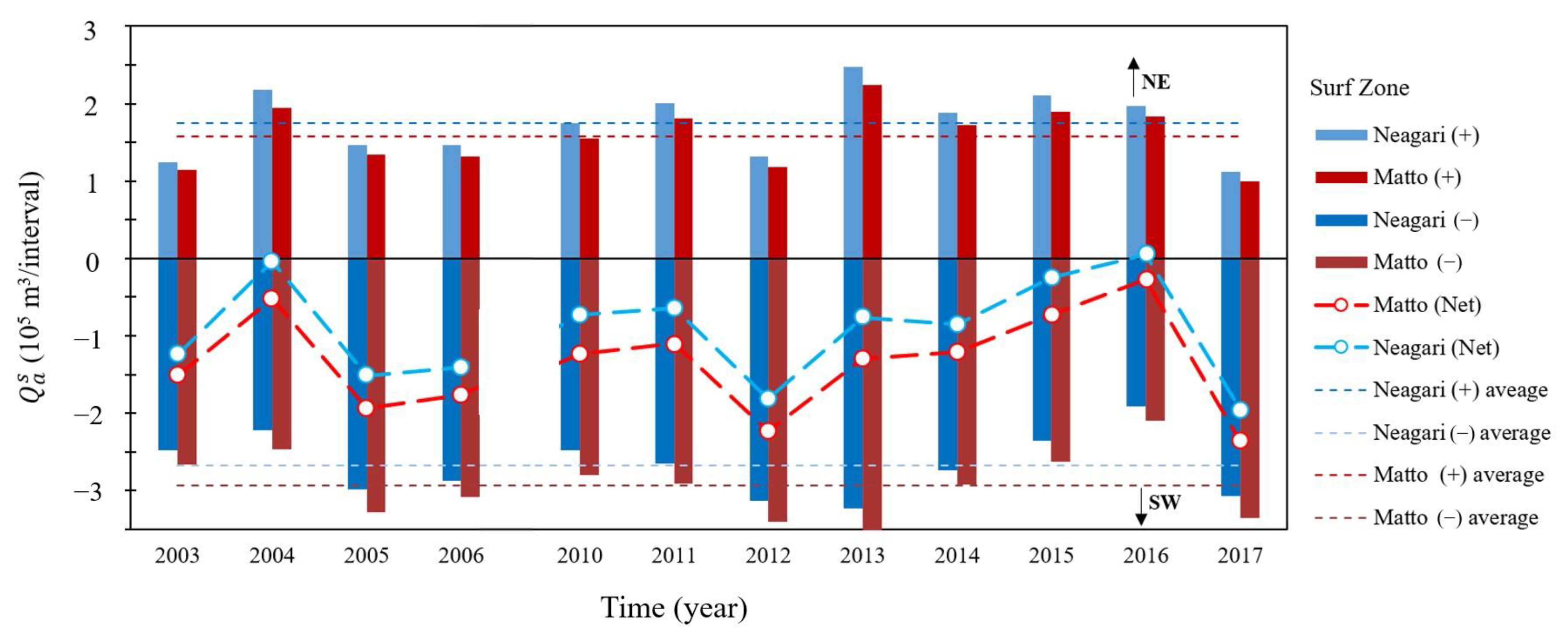
4.3. Longshore Sediment Transport in the Surf and Offshore Zones

The net longshore sediment transport, in terms of the sediment transport from the southern boundary ( Q a L S )   and northern boundary ( Q a R S ) of the surf zone and the transport at the southern boundary   ( Q a L O ) and northeastern boundary ( Q a R O ) of the offshore zone, are shown in Figure 4. The net sediment transport and the cumulative sediment transport in each direction for the surf and offshore zones are shown in Figure 7 and Figure 8, respectively. The longshore sediment transport rates were estimated using the method described in Section 3.3; we applied the sediment and topographic characteristics of the base conditions (BC) shown in Table 3 and the data of the waves and currents observed at the Tokumitsu Observatory. The longshore sediment transport in the region was positive in the northeast direction (x-axis direction = right direction in Figure 4), and the cumulative sediment transport was calculated corresponding to the interval of the bathymetric survey conducted in this study (Table 2).
In the surf zone, the average ratio of the cumulative longshore sediment transport in each direction was approximately 2 × 10⁵ m3/interval in the northeast direction and 3 × 10⁵ m3/interval in the southwest direction; the net longshore sediment transport was predominantly in the southwest direction. The Q a R S was estimated to be larger than the Q a L S . The period-averaged Q a R S and Q a L S were estimated to be 135,000 m3/year and 71,000 m3/year, respectively. Even if the directions of the offshore waves were uniform, the slightly curved shoreline of the Ishikawa coast caused a bias in the frequency of obliquely incident waves near the northeast boundary. Consequently, we estimated a difference in the net longshore sediment transport between the two boundaries of the surf zone.
In the offshore zone, the northeastward cumulative sediment transport was more dominant over the southwestward cumulative sediment transport. Therefore, the net longshore sediment transport was approximately equal to the cumulative sediment transport in the northeast direction. The Q a R O was estimated to be considerably larger than the Q a L O . The difference in the longshore sediment transport between the two boundaries was due to the spatial variation in the sediment grain size. The sediment on the coast of the right side of the Tedori River mouth was comprised mainly of fine-grained sand that was well-sorted and homogenized, whereas the sediment on the coast of the left side of the river portrayed a wider range of grain sizes and a mixture of medium- and coarse-grained sand (Figure 9). Thus, it is considered that the sediment suspension and transport at the southwestern boundary were less frequent than those at the northeast boundary. The period-average Q a R O and Q a L O were estimated to be 195,000 m3/year and 62,000 m3/year, respectively.
The main direction of the net longshore sediment transport around the Ishikawa coast was estimated to be southwest in the surf zone (dominated by wave action) and northeast in the offshore zone (dominated by current and wave action). These estimations were consistent with those conducted by Sato [27] and Tanaka et al. [25,26], which were based on the morphological evolution around coastal structures and the observations of waves and currents. The difference in the net longshore sediment transport direction between the surf and offshore zones around the Ishikawa coast continued for at least several decades. The sediment volume also exhibited different trends between the surf and offshore zones (Section 4.1). Therefore, it is essential to investigate the sediment budget of this coast by dividing the area into segments in both the alongshore and cross-shore directions.

4.4. Sediment Budget and Net Sediment Transport along the Ishikawa Coast

In this study, the long-term average sediment transport along the Ishikawa coast was investigated by examining the sediment budget in eight cells, with the surf and offshore zones being divided into four sections (individually) in the longshore direction, as shown in Figure 3 and Figure 4. Note that we assumed that the total amount of the river sediments discharged from the mouth of the Tedori River (Section 4.2) was deposited in the eight cells. It was assumed that 80% of the river sediment was supplied to cells S1–S4 in the surf zone and 20% to cells O1–O4 in the offshore zone, and the proportions of river sediments supplied to the cells adjacent to the river mouth were considered to be high (refer to the BC conditions specified in Table 3). The sediment transport at both ends of the longshore boundary was considered, based on the estimation results explained in Section 4.3. The sediment budget was analyzed over 12 years (2003–2006, 2010–2017), with data errors in both the bathymetric survey records and the wave and current observation records being insignificant; the missing data rates were less than 20%.
Furthermore, we compared the average sediment volume change over the period and the distribution of sediment transport on the Ishikawa coast between the surf and offshore zones (Figure 10). In the surf zone, the sediment volume in each cell tended to increase, with the longshore sediment transport being dominant in the southwestward direction. The increasing trends of the sediment volumes in the S2 and S3 cells, adjacent to the river mouth, were high. The net longshore sediment transport around S2 and S3 decreased considerably in the downdrift direction of the longshore sediment transport. The sediment budgets of S2 and S3 indicated sedimentation in the river mouth area, mainly resulting from the deposition of longshore drift sediments and the supply of river sediments. The sediment budget in the S1 cell indicated a balance between the river sediment supply and the discharge of the longshore drift sediments. The sediment volume in the offshore zone tended to decrease, with the longshore sediment transport dominant in the northeastward direction. The sediment volumes in O2 and O3 offshore of the river mouth portrayed a more stable trend than those in O1 and O4. The net longshore sediment transport rates of O2 and O3 were nearly constant in the longshore direction. The net longshore sediment transport rates in the surf and offshore zones, estimated from the sediment budget model, were 40,000–120,000 m3/year/km.
The net cross-shore sediment transport was landward at the offshore boundary of the surf zone and seaward at the offshore boundary of the offshore zone (Figure 10). Comparing the sediment transport rate per unit width revealed that the net cross-shore sediment transport was smaller than the net longshore sediment transport. However, on the Ishikawa coast, with a coastline of nearly 20 km, the contribution of cross-shore sediment transport to the sediment budget can be as crucial as longshore sediment transport. The sediment budget of the offshore zone represented offshore erosion due to the divergence of cross-shore sediment transport and the excessive transport of longshore drift sediment. Based on recent research findings [17,19,46] and the characteristics of the external forces in this coast, it can be analogized that wave action is dominant for the cross-shore sediment transport between the surf and offshore zones, and wave and current action is important for cross-shore sediment transport on the offshore boundary. However, the characteristics of cross-shore sediment transport could be affected by geomorphology, structures, sediment, and external forces, thus further detailed studies are needed.
The sediment budget of the Ishikawa coast in the 1980s, during the period of sand and gravel extraction in the Tedori River, was studied by Tanaka et al. [25]. They explained the sediment budget by the imbalance of longshore sediment transport (excess discharge) alone; the offshore boundary of the offshore zone was set at a depth of 30 m, and the net cross-shore sediment transport was assumed to be zero. Furthermore, the direction of longshore sediment transport in the offshore zone estimated by Tanaka et al. [25] was similar to that estimated in this study; however, the amount of longshore sediment transport estimated by Tanaka et al. [25] was more than twice the amount estimated in this study. Significant changes in the sediment budget occurred in the surf zone between the 1980s and the period after 2000. The trend of the sediment volume in the surf zone shifted from a decrease of 150,000 m3/year to an increase of 200,000 m3/year; notably, the volume of the sediment discharged from the Tedori River increased by nearly three times, after the cessation of sand and gravel extraction from the river. The sediment budget in the 1980s, analyzed by Tanaka et al. [25], indicated an erosion trend, due to a small supply of river sediment and an excessive discharge of longshore drift sediment. In contrast, the sediment budget after the 2000s, as analyzed in this study, suggests a sedimentation trend due to the deposition of longshore drift sediment and the sediment supply from the river and offshore zones.

4.5. Variability of Net Sediment Transport and Budget

The estimated results of the sediment budget were subject to uncertainty. The possible leading causes were measurement errors in the water depth, current velocity, and wave height [47], errors in the estimation of sediment volumes from limited survey data in the longshore direction, and errors in the estimation of the longshore sediment transport rate and river sediment discharge. In this study, we examined the sensitivity of the sediment budget estimated for the Ishikawa coast while focusing on the uncertainties related to the estimation errors in the coastal sediment transport and river sediment discharge used for the boundary conditions.
Additionally, we analyzed the sediment budget by applying the different boundary conditions in Table 3 to the analytical condition BC described in Section 4.4. The variations in the total amount of river sediment discharge and the fraction of sediment supplied to each area (R1–R11) were also considered. The lower limit of the river sediment volume was set to an estimated 40,000 m3/year during the peak period of river development, and the upper limit to 192,000 m3/year (from Dang et al. [43] estimations). Furthermore, the sediment median grain size, cross-shore slope, and shoreline angle (C1–C10) for calculating the longshore sediment transport rate were set to account for the range of variability in the field data. The net sediment transport rates estimated from the sediment budget analysis in these conditions are shown in Figure 11. The 22 boundary conditions for the sensitivity analysis are displayed on the horizontal axis (R1–R11 and C1–C10) in comparison to the base condition (BC) (Detailed characteristics are listed in Table 3).
The estimated amount of the net cross-shore sediment transport varied significantly with the magnitude of river sediment discharge and depended on the fraction of the river sediment supplied to each area (Figure 11a). Suppose the river sediment supplied to the surf zone was estimated to be approximately twice that in the BC, then the net cross-shore sediment transport at the boundary between the surf and offshore zones reversed into the seaward direction. The net cross-shore transport was also affected by the boundary conditions of the longshore sediment transport in the surf and offshore zones (Figure 11b). In the case of C7, the net cross-shore transport at the offshore boundary decreased to less than half of that in the BC.
For river sediment discharges below those in the BC, the estimated longshore sediment transport in the surf zone induced minor effects on the sediment fraction (Figure 11c). If the river sediment discharge was larger than that in the BC, the change in the longshore transport between S3 and S4 due to the fraction was significant. The longshore transport around the inner regions of S2 and S3 portrayed variations similar to those in the boundary conditions of the surf zone (Figure 11d). The estimated longshore transport in the offshore zone was not influenced by the boundary conditions of the surf zone (Figure 11f). However, these changes were influenced by the boundary conditions of the offshore zone and the sediment supply fraction (Figure 11e). The net longshore transport rates in the surf zone varied within the range of ±50% of those in the BC, owing to changes in the boundary conditions. In comparison, those in the offshore zone decreased by up to 80% of that in the BC.
We quantified the variation in the net sediment transport rates in the cross-shore and alongshore directions, using the maximum and minimum values of the net sediment transport rates, the interquartile range, and the median values obtained from the 22 cases, wide in magnitude. They all indicated the same direction of the longshore sediment transport in the surf zone (southwestward). The surf zone portrayed a varied gradient in the south. As opposed to the gradient of the offshore zone, the sediment transport rate portrayed a uniform trend, with the expectation that the boundary Q a R O has twice the amount of sediment transported, mainly because of the property of grain size.
Compared to the alongshore sediment transport, the surf and offshore zones portrayed a broader range of cross-shore transfer. Therefore, the changes in the boundary conditions affected the cross-shore sediment transport. For the offshore cross-shore sediment transport, in the box-chart, the longest box is displayed ( Q c O in Figure 12), indicating that the majority of its magnitude occurred within the interquartile range.

4.6. Morphological Changes on the Coasts Adjacent to the Ishikawa Coast

4.6.1. Interaction with the Southwestern Coast

The Katayamazu and Komatsu coasts adjacent to the southwestern side of the Ishikawa coast portray a long-term erosion trend, with much damage occurring in recent decades, especially at the seawalls (where the sandy beaches have been eroded extensively) [48]. Aerial photographs from 1947 portray a significant shoreline recession, approximately 10 km along the coast. The average shoreline retreat distance was ~30 m in 1975, 40 m in 1994, and 50 m in 2003, and the average annual shoreline retreat speed was approximately 1 m/yr [49]. From the bathymetric surveys conducted during 1988–2010, we observed significant erosion from the seawall to a depth of 5–6 m on the Katayamazu coast at the southwestern end of the LC.
In contrast, seabed elevation tended to increase at depths of 6–15 m. The beach slope from the shoreline to the depth of 4 m was as steep as 1/5 to 1/10, where most surface sediments consisted of pebbles and granules. The slope from the depth of 4 m to 15 m was 1/50–1/80, with medium and fine sand covering the seabed surface [50,51]. On the Komatsu coast, adjacent to the Ishikawa coast, erosion was evident up to 5–6 m. The slope of the upper shoreface increased gradually, but the sandbar topography was preserved.
In previous studies, the variations in the sediment volume on the Komatsu and Katayamazu coasts were calculated using bathymetric survey records. The results of INA [49] indicate a decreasing trend of approximately 900 m3/km/year in the surf zone and 3500 m3/km/year in the offshore zone of the Komatsu coast during 1994–2004 (Table 4). The study conducted by Uchibori et al. [51] on the Katayamazu coast indicated no long-term trend in the sediment volumes in both the surf and offshore zones during 2001–2012, suggesting that the sediment budget was in a state of equilibrium.
The Katayamazu coastline angle is bigger than that of the Ishikawa coastline, and the energy of the waves is incident from the left and right and is balanced with respect to the orthogonal direction of the coastline (see Figure 2). Therefore, the net longshore sediment transport in the surf zone of the Katayamazu coast was smaller than that of the adjacent Komatsu and Ishikawa coasts. In general, in the case of the Katayamazu coast, the volume of longshore drifting sand flowing into and out of the surf zone is limited because of the Kasanomisaki Cape and rocky reef at the southwestern end of the coast. Regarding the extent of sediment deposition discharged from the Tedori River Basin, Ohmura and Sato [52] described the boundary as the Kasanomisaki Cape, with distinct spatial variations in the sand color and grain size, based on their sediment survey around the shoreline. The net longshore sediment transport between the Katayamazu and Komatsu coasts was estimated to be in a southwesterly direction. This dominant direction was determined from the relationship between the wave and shoreline directions, and the morphology around the jetties at the mouths of the Shinbori and Kakehashi rivers. The sediment budget of the Katayamazu and Komatsu coasts and their relationship with the Ishikawa coast were discussed, based on the estimated results of the sediment volume change and transport direction.
Because the amount of sediment in the surf zone of the Katayamazu coast is relatively stable, as described in the above paragraphs, we assumed that the volume of sediment equivalent to the net longshore sediment transported from the Komatsu coast was transferred from the surf zone to the offshore zone of the Katayamazu coast (Figure 13). The net longshore sediment transport in the offshore zone of the Komatsu and Katayamazu coasts was expected to be northeastward, because of the influence of the offshore coastal current, similar to that observed on the Ishikawa coast. Consequently, some sediment transported in the southwest direction from the surf zone on the Ishikawa coast could have reached the Katayamazu coast, where the fine-grained sand component was transferred to the offshore zone, while some of the sediment would have returned to the Ishikawa coast. A comparable sediment transport pattern was devised by Tanaka et al. [25], based on the sediment balance relationship of the Ishikawa coast in the 1970s. This net sediment transport pattern in the SLC was maintained over a long-term period.

4.6.2. Interaction with the Northeastern Coast

The Kanazawa Port and its surrounding coast on the northern side of the Ishikawa coast have the most significant sediment accumulation in the LC. The Kanazawa Port is an excavated port constructed in 1965. When the port was opened in 1970, a breakwater of approximately 1300 m protruded in the northeast direction. The breakwater extended with the development of the port, reaching 3210 m in 2015. The water depth at the head of the breakwater is 13–14 m. The sediment volume of the coast around Kanazawa Port was calculated by INA [49] using bathymetric survey records (see Table 4). The sediment volume during 1991–2003 increased by approximately 140,000 m3/year (on average). Sedimentation was also significant within the Kanazawa Port inside the breakwater, with an increase of approximately 40,000 m3/year in the area around the opening of the port. On the Uchinada coast adjacent to the north side of the Kanazawa Port, the shoreline and isobaths shifted offshore (Figure 14). The shoreline of 1.5 km in the vicinity of the Kanazawa Port has moved more than 100-m offshore in the 30 years since 1975 [53].
Based on the observations of morphological changes and nearshore external forces, we infer two leading causes of sedimentation at the Kanazawa Port and the surrounding coast. First, the sediment supplied by northeastward offshore currents from the offshore zone of the Ishikawa coast was partially intercepted by the Kanazawa Port breakwater and deposited on the offshore seabed of the Kanaiwa coast and around the breakwater head. Second, sediments were mainly deposited along the Uchinada coast and in Kanazawa Port because of the southwestward longshore sediment transport by waves in the surf zone north of the Uchinada coast, intercepted by the seawall and jetty at the eastern end of Kanazawa Port. The direction of sediment transport around the Kanazawa Port was estimated by Mizumura et al. [54], based on an analysis of the chemical elemental composition of the sediment, and the results were consistent with the previous estimation. The sediment volume on the southwestern side of the Kanazawa Port breakwater and offshore of the breakwater head increased by an average of approximately 90,000 m3/year during 1990–2003 (Table 4). This amount corresponded to almost half of the annual sediment transport (195,000 m3/year) from the northern boundary of the offshore zone used in our sediment budget analysis of the Ishikawa coast. The other half of the annual sediment transport was carried off the Kanazawa Port breakwater and supplied to the Uchinada and northern Kaetsu coast (Figure 13). Some of the sediments deposited in the surf zone of the Kanaiwa coast may have been transported to the Kanazawa and Ishikawa coasts by southward longshore sediment transport.
The sediment budget of the Kanazawa coast was investigated to understand the possible sources of sediment transport into the surf zone on the northeast boundary of the Ishikawa coast. Note that the Kanazawa coast is adjacent to the Kanaiwa coast on the northeastern boundary, where the mouth of the Sai River is located. A 900-m-long jetty exists on the left side of the river mouth. The Kanazawa coast, which extends for 4.3 km, is protected by detached breakwaters. The cross-shore slope in this region is lowest on the southern coast of the Kanazawa Port, at 1/110, with sandbars formed offshore of the detached breakwaters. The direction of the shoreline was almost the same as that of the adjacent Matto area on the Ishikawa coast, and the longshore sediment transport in the surf zone was predominantly in the southwest direction. Aerial photographs from 1947 portray a significant shoreline recession in the early 1970s. The construction of the Kanazawa Port and the extension of the Sai River jetties are considered to be directly responsible for the disruption of the sediment transport from the northeastern coast. The breakwaters were constructed from the north side of the Kanazawa coast, the second installed in 1973, the fifth in 1983, and the 13th completed in 2002.
The sediment volume in the shore-side area of the detached breakwaters was expected to be stable in recent years. The sediment volume on the offshore side of the detached breakwater decreased by an annual average of 4300 m3/km during 1990–2002 (Table 4). As no subsequent survey records are available, the trend of the sediment volume change in recent years remains unknown. However, we can assume that the decreasing trend in the sediment volume of the surf zone did not change substantially, considering the recent implementation of massive wave-dissipating blocks on the detached breakwaters. As there are no survey records for the offshore zone of the Kanazawa coast in relation to the recession trend of the contours at the depths of 15 and 20 m offshore of the Sai River (Figure 14), and due to the decreasing trend of the sediment volume in the offshore zone of the Matto area of the Ishikawa Coast, the sediment volume in the offshore zone of the Kanazawa Coast is likely to decrease in the future. The sediment budget in the surf zone of the Kanazawa coast depends on the balance between the sediment supply from the offshore zone and the Kanaiwa Coast and the sediment transport into the Ishikawa coast. Considering the dominant direction of longshore sediment transport in the surf zone, we could infer that the longshore sediment transport from the Kanazawa coast to the Ishikawa Coast is substantial (Figure 13).

4.7. Net Sediment Transport and Regional Sediment Budget in the Southern Part of the Littoral Sediment Cell (SLC) Considered in This Study

To understand the dominant direction of sediment transport and the trend of sediment volume change in the SLC after the 1990s, we summarized the results of our analysis of the Ishikawa and its adjacent coasts in Figure 13 and Table 4. The vectors in Figure 13 represent sediment transport in the longshore and cross-shore directions, respectively. The magnitude of the vectors was determined by considering the trend of sediment volume change in each zone. Figure 9 portrays the representative grain sizes and fractions of fine-grained sand in the sediments sampled at 5 m and 15 m. The horizontal axis shown in Figure 9 represents the longshore distance, defined as the reference point at the mouth of the Tedori River.
The surf zone within 1 km of the shoreline, where the water depth was less than 10–13 m, is dominated by southwestward longshore sediment transport, owing to wave action. The sediment volume updrift of the longshore sediment transport on the Kanazawa coast portrayed a decreasing trend. This was mainly because the amount of sediment supplied from the Kanaiwa coast was smaller than that of the sediment discharged into the Ishikawa coast. We assumed that the longshore sediment transport was obstructed by the jetty at the mouth of the Sai River (see Figure 14). In contrast, the sedimentation tendency was significant in the surf zone of the Ishikawa coast, especially in the Mikawa area. The annual average rate of increase in the sediment volume estimated from the bathymetry records was equivalent to approximately 50% of the average sediment discharge from the Tedori River (100,000 m3/year) estimated in the sediment budget analysis conducted in this study. The amount of sediment in the Mikawa area, where the mouth of the Tedori River was located, increased significantly.
In comparison, the sediment volume on the Neagari coast, downdrift of the longshore sediment transport, increased at a lower rate (Table 4). Compared to the sediment volume in the adjacent areas, the volume in the Mikawa area decreased significantly, due to the impact of gravel extraction in the Tedori River until 1990 (Figure 5). Although the cessation of sand and gravel extraction rapidly improved the amount of sediment in the Mikawa area, the amount of sediment supplied to the adjacent areas did not increase significantly. Note that most sediment supplied to the SLC originated from the Tedori River. The other rivers had significantly smaller catchment and sediment production areas than the Tedori River, with a lower river discharge, and thus had a smaller impact on the sediment volume on the coast.
The sediments in the offshore zone were transported northeastward, by the combined effects of waves and coastal currents. Coarse- and medium-grained sand grains were dominant in the Komatsu coast and Neagari areas, whereas finer-grained sand grains having a uniform size were dominant on the coasts along the right side of the Tedori River mouth (Figure 9b). Consequently, sediment transport was more prominent in the Matto area than in the Komatsu coast and Neagari areas. The imbalance in the amount of longshore transported sand caused offshore erosion on the Komatsu and Ishikawa coasts. The sediments at depths more than 15–20 m on the Ishikawa coast were larger than the surf zone’s average grain size (Figure 15). This was due to the erosion of the offshore seabed after the 1980s, which exposed old land sediments more than 8000 years ago when the sea level was more than 20 m below the present level [37]. The offshore zone has been eroding for the last 20 years, and it is possible that the seafloor covered with coarse-grained sediments extends into the surrounding area. This is due to the sand being transported by waves and currents. This will change the sediment budget of the coasts’ downdrift of sediment transport. As a result of the changes in the coastal currents around the Kanazawa Port due to the effects of breakwaters and other structures, fine-grained sand was deposited on the Kanaiwa coast and around the Kanazawa Port breakwater (Figure 14). If the sediment coarsening in the offshore zone of the Ishikawa coast progresses further in the future, the increasing trend of the sediment volume of the Kanaiwa coast will weaken, leading to a possible decrease in the sediment volume transported to the northern LC through the offshore breakwater of the Kanazawa Port.
In the SLC, the dominant directions of longshore sediment transport in the surf and offshore zones were opposite, indicating that in this region sediments could be transported in a clockwise circular motion between the Kanazawa Port and Kasanomisaki Cape. Some sediment passed through the offshore side of the breakwater of the Kanazawa Port and was transported to the Uchinada and northeastern coasts. Note that silt, which is commonly contained in turbid waters during river floods, was not commonly found in the sediments of the surf and offshore zones (Figure 9). However, silt was diffused and deposited on the northern coast and inner shelf, because of its low sedimentation rate (compared to sand). As the inner shelf was subjected to a strong northeastward current throughout the year, we assumed the sediments would move in the same direction. The northern LC, located north of the Kanazawa Port, comprises nearly 30 km of sandy beaches, with multiple sandbars [55]. The shoreline around the Chirihama coast at the northern end of the LC has been retreating for decades [56]. Estimating sediment transport to the northern coast from the Kanazawa Port and clarifying the sediment budget of the entire LC is vital for future coastal sediment management.

5. Conclusions

Long-term variations in the coastal sediment volumes of the Ishikawa Coast were investigated over several decades. Sediment volume in the offshore zone has been affected by sediment management in the Tedori River basin and the surf zone. The cessation of fluvial gravel extraction has stabilized the sediment volume in the surf zone and recovered the sediment volume in the left side area of the river mouth, S2. Furthermore, it has mitigated the significant decreasing trend of sediment volume in the offshore zone. The erosion during Periods 1 and 2 was the most pronounced on the right side of the river mouth, O3, while the erosion trend during Period 3 approached the comparable level with the adjacent area of O3. River sediment could be transported mainly to adjacent downdrift areas in each zone, because the sediment volume variations in S2 and O3 on the left and right sides of the river mouth significantly influence river sediment management.
The sediment budget analysis for Period 3 considered differences in the basic characteristics of sediment volume variation and sediment transport between the surf and offshore zones. The surf zone budget indicated increasing trends in coastal sediment volume, mainly due to river sediment supply and the dominant inflow of longshore sediment transport. In contrast, the offshore zone budget indicated a decreasing trend in sediment volume due to the dominant outflow components of longshore and cross-shore sediment transports and limited river sediment supply. The results of the budget analysis are adequate for understanding the quantitative balance between the sediment volume variation in each sub-cell of the coast and the net sediment transport. The net sediment transport rate was estimated by considering the uncertainty of the boundary conditions for the river and coast in the sediment budget analysis. The results help to assess the range of uncertainty in the estimated longshore and cross-shore sediment transport rates derived from the sediment budget analysis.
The summary and integration of the present findings on the Ishikawa coast with those of previous studies on the surrounding coasts facilitate comprehension of the regional sediment budget trend and sediment transport pathway in the SLC. The erosion trend is widely distributed, mainly in the offshore zone of the Ishikawa and adjacent coasts. In contrast, sediment accretion occurs intensively in the surf zone around the mouth of the Tedori River and the areas around the Kanazawa Port. The accretion around the port is attributed to the concentration of longshore drift sand supplied from the offshore zone of the SLC and the surf zone of the Northern Kaetsu coast. The various possible sediment transport pathways were considered according to the directions of the net sediment transport estimated from the spatial distribution of sediment volume trends and the main directions of the external forces. One of the characteristic transport pathways on the SLC is a clockwise circulation pattern for regional sediment transport between Kanazawa Port and Kasanomisaki Cap. The regional sediment transport pattern reflects the external force characteristics of the SLC, where offshore currents develop in the opposite direction to the wave-induced currents in the surf zone.
The estimated trend of each coastal sediment volume within the SLC (Table 4) has different accuracy due to the different periods and resolutions of the bathymetric survey records used for the volume calculations. The sediment budget model for the Ishikawa coast assumes that the cross-shore sediment transport rate per unit width is uniform in the longshore direction. Notwithstanding these limitations, this study provides an assessment of cross-shore sediment transport, regional sediment budget and sediment transport pathways by considering the differences in sediment volume trends and sediment transport characteristics between the surf and offshore zones of the SLC. This study provides useful knowledge for developing sustainable conservation methods for sandy beaches throughout the LC, efficient maintenance and renewal of structures for coastal protection, and comprehensive sediment management plans for the coasts and rivers. The assessment framework of this study can be expected for application to other coasts.

Author Contributions

The authors designed the framework for the analysis together: T.T. analyzed the data and wrote the manuscript; S.U. guided the study and provided suggestions and improvements to the manuscript; M.Y. provided suggestions and improvements to the manuscript. All authors have read and agreed to the published version of the manuscript.

Funding

The study was partially supported by a Grant-Aid for Scientific Research from the Japan Society for the Promotion of Science (No. 20HO2256).

Institutional Review Board Statement

Not applicable.

Informed Consent Statement

Not applicable.

Data Availability Statement

Data sets are contained within the article. Further data and materials should be addressed to [email protected] (S.U.)

Acknowledgments

The authors extend their gratitude to the Hokuriku Regional Development Bureau, Ministry of Land, Infrastructure and Transport of Japan, for providing the field data, and to Mamoru Arita for his support of the coastal sediment survey. Additionally, we would like to thank Editage for English language editing.

Conflicts of Interest

The authors declare no conflict of interest.

References

  1. Boateng, I.; Bray, M.; Hooke, J. Estimating the fluvial sediment input to the coastal sediment budget: A case study of Ghana. Geomorphology 2012, 138, 100–110. [Google Scholar] [CrossRef]
  2. Cooper, N.J.; Hooke, J.M.; Bray, M.J. Predicting coastal evolution using a sediment budget approach: A case study from southern England. Ocean. Coast. Manag. 2001, 44, 711–728. [Google Scholar] [CrossRef]
  3. Rosati, J.D. Concepts in sediment budgets. J. Coast. Res. 2005, 21, 307–322. [Google Scholar] [CrossRef]
  4. Restrepo, J.D.; Escobar, R.; Tosic, M. Fluvial fluxes from the Magdalena River into Cartagena Bay, Caribbean Colombia: Trends, future scenarios, and connections with upstream human impacts. Geomorphology 2018, 302, 92–105. [Google Scholar] [CrossRef]
  5. Willis, C.M.; Griggs, G.B. Reductions in fluvial sediment discharge by coastal dams in California and implications for beach sustainability. J. Geol. 2003, 111, 167–182. [Google Scholar] [CrossRef]
  6. Cappucci, S.; Bertoni, D.; Cipriani, L.E.; Boninsegni, G.; Sarti, G. Assessment of the Anthropogenic Sediment Budget of a Littoral Cell System (Northern Tuscany, Italy). Water 2020, 12, 3240. [Google Scholar] [CrossRef]
  7. Byrnes, M.R.; Hiland, M.W. Large-scale sediment transport patterns on the continental shelf and influence on shoreline response: St. Andrew Sound, Georgia to Nassau Sound, Florida, USA. Mar. Geol. 1995, 126, 19–43. [Google Scholar] [CrossRef]
  8. Sanderson, P.G.; Eliot, I. Compartmentalisation of beachface sediments along the southwestern coast of Australia. Mar. Geol. 1999, 162, 145–164. [Google Scholar] [CrossRef]
  9. Eittreim, S.L.; Xu, J.; Noble, M.; Edwards, B.D. Towards a sediment budget for the Santa Cruz shelf. Mar. Geol. 2002, 181, 235–248. [Google Scholar] [CrossRef]
  10. Limber, P.W.; Patsch, K.B.; Griggs, G.B. Coastal Sediment Budgets and the Littoral Cutoff Diameter: A Grain Size Threshold for Quantifying Active Sediment Inputs. J. Coast. Res. 2008, 24, 122–133. [Google Scholar] [CrossRef]
  11. Thornton, E.B. Temporal and spatial variations in sand budgets with application to southern Monterey Bay, California. Mar. Geol. 2016, 382, 56–67. [Google Scholar] [CrossRef]
  12. Shetty, A.; Kankara, R.S.; Silamaban, D.; Subbiah, B.; Subburaj, S. Implication of shoreline and nearshore morphological changes on sediment budget of wave-dominated Chennai beach, India. Environ. Earth Sci. 2022, 81, 505. [Google Scholar] [CrossRef]
  13. Soomere, T.; Viška, M. Simulated wave-driven sediment transport along the eastern coast of the Baltic Sea. J. Mar. Syst. 2014, 129, 96–105. [Google Scholar] [CrossRef]
  14. van Rijn, L.C. Sediment transport and budget of the central coastal zone of Holland. Coast. Eng. 1997, 32, 61–90. [Google Scholar] [CrossRef]
  15. Patsch, K.; Griggs, G. A sand budget for the Santa Barbara Littoral Cell, California. Mar. Geol. 2008, 252, 50–61. [Google Scholar] [CrossRef]
  16. Pomeroy, A.W.M.; Lowe, R.J.; Van Dongeren, A.R.; Ghisalberti, M.; Bodde, W.; Roelvink, D. Spectral wave-driven sediment transport across a fringing reef. Coast. Eng. 2015, 98, 78–94. [Google Scholar] [CrossRef]
  17. Ding, Y.; Styles, R.; Kim, S.C.; Permenter, R.L.; Frey, A.E. Cross-shore sediment transport for modeling long-term shoreline evolution. J. Waterw. Port Coast. Ocean Eng. 2021, 147, 04021014. [Google Scholar] [CrossRef]
  18. Broekema, Y.B.; Giardino, A.; van der Werf, J.J.; van Rooijen, A.A.; Vousdoukas, M.I.; van Prooijen, B.C. Observations and modelling of nearshore sediment sorting processes along a barred beach profile. Coast. Eng. 2016, 118, 50–62. [Google Scholar] [CrossRef]
  19. Grossmann, F.; Hurther, D.; van der Zanden, J.; Cáceres, I.; Sánchez-Arcilla, A.; Alsina, J.M. Near-bed sediment transport during offshore bar migration in large-scale experiments. J. Geophys. Res. Ocean. 2022, 127, e2021JC017756. [Google Scholar] [CrossRef]
  20. Montreuil, A.L.; Bullard, J.E. A 150-year record of coastline dynamics within a sediment cell: Eastern England. Geomorphology 2012, 179, 168–185. [Google Scholar] [CrossRef]
  21. Kana, T.W. A mesoscale sediment budget for Long Island, New York. Mar. Geol. 1995, 126, 87–110. [Google Scholar] [CrossRef]
  22. Sunamura, T.; Horikawa, K. Sediment budget in Kujukuri coastal area, Japan. ASCE 1977, 77, 4. [Google Scholar]
  23. Torii, K.; Sato, S.; Uda, T.; Okayasu, T. Regional sediment management based on sediment budget for graded sediments-A study case of Tenryu watershed and Enshu-Nada coast. In Proceedings of the Coastal Engineering Conference (ICCE2004), Lisbon, Portugal, 19–24 September 2004; pp. 3110–3122. [Google Scholar]
  24. Hiep, N.T.; Tanaka, H.; Tinh, N.X. Centennial to Multi-Decadal Morphology Change and Sediment Budget Alteration with Consideration of the Impacts of the 2011 Tohoku Earthquake Tsunami along the Nobiru Coast, Japan. J. Mar. Sci. Eng. 2021, 9, 265. [Google Scholar] [CrossRef]
  25. Tanaka, S.; Sato, S.; Kawagishi, S.; Ishikawa, T.; Yamamoto, Y.; Asano, G. Sand transport mechanism in Ishikawa Coast. Proc. Coast. Eng. JSCE 1997, 44, 661–665. (In Japanese) [Google Scholar]
  26. Tanaka, S.; Sato, S.; Kawagishi, S.; Ishikawa, T.; Yamamoto, Y. Sediment transport mechanism offshore of Ishikawa Coast. Proc. Coast. Eng. JSCE 1996, 44, 551–555. (In Japanese) [Google Scholar]
  27. Sato, S. Effects of winds and breaking waves on large-scale coastal currents developed by winter storms in Japan Sea. Coast. Eng. Jpn. 1996, 39, 129–144. [Google Scholar] [CrossRef]
  28. Yasuda, T.; Mori, N.; Kato, S.; Sato, S. Characteristics of offshore currents and effects of wave breaking on Ishikawa Coast. Proc. Coast. Eng. JSCE 1995, 45, 431–435. (In Japanese) [Google Scholar]
  29. Uda, T.; Kumada, T.; Serizawa, M. Large-scale circulation of littoral drift on coast with seasonal changes in wave direction and amplitude. J. Coast. Res. 2009, SI56, 143–147. [Google Scholar]
  30. Yuhi, M. Impact of anthropogenic modifications of a river basin on neighboring coasts: Case study. J. Waterw. Port Coast. Ocean. Eng. 2008, 134, 336–344. [Google Scholar] [CrossRef]
  31. Yuhi, M.; Dang, M.H.; Umeda, S. Comparison of accelerated erosion in riverbed and downstream coast by EOF analysis. J. Coast. Res. 2013, SI65, 618–623. [Google Scholar] [CrossRef]
  32. Wright, L.D.; Short, A.D. Morphodynamic variability of surf zones and beaches: A synthesis. Mar. Geol. 1984, 56, 93–118. [Google Scholar] [CrossRef]
  33. Nishikawa, S.; Wakamatsu, T.; Ishizaki, H.; Sakamoto, K.; Tanaka, Y.; Tsujino, H.; Yamanaka, G.; Kamachi, M.; Ishikawa, Y. Development of high-resolution future ocean regional projection datasets for coastal applications in Japan. Prog. Earth Planet. Sci. 2021, 8, 7. [Google Scholar] [CrossRef]
  34. Umeda, S.; Ninomiya, J.; Arita, F.; Yuhi, M. Seasonal Variability of the Currents in the Offshore Region of Surf Zone and Effects of External Forcings on the Currents. J. Jpn. Soc. Civ. Eng. Ser. B2 (Coast. Eng.) 2021, 77, 355–360. (In Japanese) [Google Scholar] [CrossRef] [PubMed]
  35. Nguyen, C.T.; Yuhi, M. Long-term variation of wave characteristics on the Kaetsu coast, Japan. J. Jpn. Soc. Civ. Eng. Ser. B3 (Ocean. Eng.) 2015, 71, I_359–I_364. [Google Scholar] [CrossRef] [PubMed]
  36. Dang, M.; Umeda, S.; Yuhi, M. Long-term riverbed response of lower Tedori River, Japan, to sediment extraction and dam construction. Environ. Earth Sci. 2014, 72, 2971–2983. [Google Scholar] [CrossRef]
  37. Umeda, S.; Arita, M.; Thunyaphun, T.; Do, Q.; Yuhi, M. Spatial distribution of grain-size of surface sediments and morphologi- cal change in Ishikawa Coast. J. JSCE (B2: Coast. Eng.) 2022, 78, 583–588. (In Japanese) [Google Scholar]
  38. Kamphuis, J.W. Alongshore sediment transport rate. J. Waterw. Port Coast. Ocean. Eng. 1991, 117, 624–640. [Google Scholar] [CrossRef]
  39. U.S. Army Corps of Engineers. Shore Protection Manual; Coastal Engineering Research Center, U.S. Government Printing Office: Washington, DC, USA, 1984.
  40. Soulsby, R. Dynamics of Marine Sands; Thomas Telford Publishing: London, UK, 1997. [Google Scholar]
  41. Zyserman, J.A.; Fredsøe, J. Data analysis of bed concentration of suspended sediment. J. Hydraul. Eng. 1994, 120, 1021–1042. [Google Scholar] [CrossRef]
  42. Soulsby, R.; Whitehouse, R. Threshold of sediment motion in coastal environments. In Pacific Coasts and Ports’ 97: Proceedings of the 13th Australasian Coastal and Ocean Engineering Conference and the 6th Australasian Port and Harbour Conference; Centre for Advanced Engineering, University of Canterbury: Christchurch, NZ, USA, 1997; Volume 1, pp. 149–154. [Google Scholar]
  43. Dang, M.; Umeda, S.; Yuhi, M. Human impact on morphology and sediment budget in the Tedori River, Japan. Adv. River Sediment Res. 2013, 9, 289–297. [Google Scholar]
  44. Tsujimoto, T.; Teramoto, A. Transitional change in vegetation and bar-morphology comparison between gravel-bed river and sandy river. J. Hydro-Environ. Res. 2004, 30, 1–9. [Google Scholar]
  45. Dang, M.H.; Umeda, S.; Yuhi, M. Morphological Changes of the Lower Tedori River, Japan, over 50 Years. Water 2019, 11, 1852. [Google Scholar]
  46. Kuang, C.; Han, X.; Zhang, J.; Zou, Q.; Dong, B. Morphodynamic evolution of a nourished beach with artificial sandbars: Field observations and numerical modeling. J. Mar. Sci. Eng. 2021, 9, 245. [Google Scholar] [CrossRef]
  47. van Rijn, L.C.; Grasmeijer, B.; Ruessink, B. Measurement errors of instruments for velocity, wave height, sand concentration and bed levels in field conditions. In Coast 3D Report for Rijkswaterstaat RIKZ; Deltares (WL)—Utrecht University: Delft, The Netherlands, 2000; pp. 1–47. [Google Scholar]
  48. Saitoh, T.; Matsubara, T. Disaster occurrence prediction for coastal structures using characteristics of wave history. J. Jpn. Soc. Civ. Eng. Ser. B2 (Coast. Eng.) 2014, 70, 1026–1030. (In Japanese) [Google Scholar]
  49. INA, C.I. Sediment dynamics analysis of Kaetsu Coast. In Report for Kanazawa Office of Rivers and National Highways; HRDB: Niigata, Japan, 2006; p. 205. (In Japanese) [Google Scholar]
  50. Jinda, T.; Hoshino, Y.; Uda, T.; Ishikawa, T.; Sannami, T.; Hanada, M. Analysis of beach changes after gravel nourishment on Katayamazu coast. J. Jpn. Soc. Civ. Eng. Ser. B2 (Coast. Eng.) 2018, 74, 895–900. (In Japanese) [Google Scholar] [CrossRef] [PubMed]
  51. Uchibori, S.; Fujita, K.; Fukuda, T.; Jinbo, M.; Sawaki, S.; Hara, F. Basic studies to develop artificial beach nourishment suitable to natural sediment transport in the Katayamazu area of the Ishikawa Coast. J. Jpn. Soc. Civ. Eng. Ser. B2 (Coast. Eng.) 2016, 72, 841–846. (In Japanese) [Google Scholar]
  52. Ohmura, M.; Sato, S. Long-term sediment transport in Kuzuryu river and Kaetsu coast under Holocene sea level variation. Coast. Eng. Proc. 2014, 1, 57. [Google Scholar] [CrossRef]
  53. Yuhi, M.; Watanabe, M.; Yoshizaki, H.; Matsuyama, M.; Kurosaki, H. Spatio-Temporal shoreline variability on the Uchinada coast, Ishikawa, Japan. J. Jpn. Soc. Civ. Eng. Ser. B3 (Ocean. Eng.) 2014, 70, 672–677. (In Japanese) [Google Scholar]
  54. Mizumura, K.; Yamamoto, T.; Fujikawa, T. Prediction of Sand Movement near Port of Kanazawa. J. Waterw. Port Coast. Ocean. Eng. 1997, 123, 215–222. [Google Scholar] [CrossRef]
  55. Yuhi, M.; Matsuyama, M.; Hayakawa, K. Sandbar Migration and Shoreline Change on the Chirihama Coast, Japan. J. Mar. Sci. Eng. 2016, 4, 40. [Google Scholar] [CrossRef]
  56. Umeda, S.; Yuhi, M.; Karunarathna, H. Seasonal to Decadal Variability of Shoreline Position on a Multiple Sandbar Beach. J. Coast. Res. 2018, SI85, 261–265. [Google Scholar] [CrossRef]
Figure 1. Locations of the Ishikawa coast, its surrounding coasts, and the Tedori River. The left aerial view depicts the position of the Ishikawa coast against a larger scale of Japan. The central diagram depicts the compartment shapes of study locations. The right diagram depicts the study details with the location of the Tokumitsu Marine Observatory.
Jmse 11 00621 g001
Figure 2. External forces on the littoral sediment cell (LC): (a) annual average velocity distribution in 2001 (m/s) and contours of 50-m intervals (b) wind velocity (m/s) (c) current velocity (m/s) (d) wave height (m) recorded at the Tokumitsu Observatory during 1996–2017.
Jmse 11 00621 g002
Figure 3. Bathymetric map of the study area in Ishikawa coast area, along with the average bed elevation during 1996–2017. The orange ticks illustrate all 49 survey lines, with an average distance between them of 400 m in the longshore direction.
Jmse 11 00621 g003
Figure 4. Sediment budget system for the Ishikawa coast analyzed in this study. The black arrows stand for all input data, both for longshore sediment transport and sediment disharge from Tedori river. The blue arrows represent all unknown variables for sediment transport rates between each cell in longshore and cross-shore directions.
Jmse 11 00621 g004
Figure 5. Cumulative temporal variation in the sediment volumes on the Ishikawa coast and the Tedori River from 1969 to 2017: (a) cumulative temporal variation of sediment volume along the coast and river, (b) coastal sediment volumes in the surf and offshore zones, (c) surf zone sediment volume in each cell, and (d) offshore zone sediment volume in each cell.
Jmse 11 00621 g005
Figure 6. Temporal variations in the sediment discharge from Tedori River during 1998 to 2017. For the whole period, the average sediment discharge was estimated to be 10 × 104 m3.
Jmse 11 00621 g006
Figure 7. Cumulative and net sediment transport in the surf zone, both cumulative and net value in each interval (calculated approximately once a year based on the date of bathymetric surveys conducted annually). Since sediment moves in both directions, the positive and negative terms are displayed in addition to the value’s sum.
Jmse 11 00621 g007
Figure 8. Cumulative and net sediment transport in the offshore zone, both cumulative and net value in each interval (calculated approximately once a year based on the date of bathymetric surveys conducted annually). Since sediment moves in both directions, the positive and negative terms are displayed in addition to the value’s sum.
Jmse 11 00621 g008
Figure 9. Longshore variations in the sediment grain size in the: (a) surf zone and (b) offshore zone, at depths of 5 m and 15 m.
Jmse 11 00621 g009
Figure 10. The sediment budget of the Ishikawa coast estimated in relation to the base condition (BC). The arrow value denotes net sediment transport, and the square value shows sediment volume change. The values in the blanket depict the supplied river sediment.
Jmse 11 00621 g010
Figure 11. Net sediment transport rate estimated from the sensitivity analysis of sediment budget: (a) cross-shore sediment transport (river effect), (b) cross-shore sediment transport (coastal effect), (c) surf zone sediment transport (river effect), (d) surf zone sediment transport (coastal effect), (e) offshore zone sediment transport (river effect), and (f) offshore zone sediment transport (coastal effect). Sediment transport from the southern boundary ( Q a L S ) and northern boundary ( Q a R S )   into the Ishikawa coast, net sediment transport from the southern boundary Q a L O and northeastern boundary ( Q a R O ) . All the sensitivity analysis cases are represented on the horizontal axis in comparison to the base case. The river effect is shown in the left column, while the coastal effect is shown in the right column.
Jmse 11 00621 g011
Figure 12. Net sediment transport rates along the longshore in the surf zone, offshore zone, and the cross-shore sediment transport rate; (LTS: longshore sediment transport). Within each box, horizontal black x-mark denote mean values; the outliers are shown as a dot for each parameter.
Jmse 11 00621 g012
Figure 13. Schematic representation of accretion and erosion along with net sediment transport in the southern part of littoral sediment cell (SLC) analyzed in this study.
Jmse 11 00621 g013
Figure 14. Long-term evolution of the bathymetric profile around Kanazawa Port. Water depth lines corresponding to 5, 10, 15, and 20 m, with the shoreline for 1979, 1994, and 2020.
Jmse 11 00621 g014
Figure 15. Beach profiles from a reference point of the survey to the cross-shore distance of 2500 m during 1960–2017 with the sediment sampling points. The dotted lines show the grain size characteristics of each sampling point including d16, d50, and d84.
Jmse 11 00621 g015
Table 1. Sediment volume trend on the Ishikawa coast, as observed in this study. The first period runs from 1969 to 1980, the second from 1980 to 1996, and the third from 1996 to 2017.
Sediment Volume Trend per Unit Alongshore Length in Each Area (103 m3/km/Year)
CellsLongshore Distance (km)Period 1Period 2Period 3
All area19.1−39.7−20.9−3.21
Surf zone19.1−22.8−9.563.1
Offshore19.1−16.9−20.9−6.31
S15.7−8.48−10.40.717
S22.7−44.5−18.215.69
S32.7−67.5−0.5123.34
S48.0−10.7−9.100.47
O15.7−17.9−9.96−9.24
O22.7−20.9−4.77−9.59
O32.7−38.9−18.3−6.07
O48.0−7.34−35.0−3.20
Table 2. Correlation of sediment volume change and cumulative river discharge for the entire area, surf zone and offshore zone, and each of the eight cells.
TermQcr(m3)All Area
19 years *00.435
19 years *300.439
13 years **300.641
Surf zoneOffshore zone
19 years *00.5040.306
19 years *300.5190.299
13 years **300.7830.431
S1S2S3S4O1O2O3O4
19 years *00.4620.5830.3430.4090.3260.3670.3620.178
19 years *300.4750.4750.3530.4180.310.4020.3920.155
13 years **300.8780.8780.4680.6490.4170.4430.4760.345
* 19 years are from 1998 to 2017 omitting 2007. ** 13 years are from 1998 to 2017 omitting 2001, 2004, 2007–2009, 2013 and 2016. 2001, 2004, 2013, 2016 are omitted due to significant coastal sediment transports. 2007–2009 are omitted due to the high missing rate.
Table 3. River and coastal boundary conditions for the sensitivity analysis of the sediment budget of the Ishikawa coast.
CasesConditions
BCbase condition, particle diameter d50 = 0.3 mm (surf zone), 0.22 (offshore zone left end),
0.18 (offshore zone right end), cross-shore slope 1/100, shoreline angle 40° (left end),
37° (right end) with 10 × 104 m3/year of rate of sediment from river
(80% for Cell S1–S4, 20% for Cell O1–O4) river sediment fraction = 16%, 24%, 24%, 16%
(for surf zone) and = 0%, 10%, 10%, 0% (for offshore zone) respectively
R1river sediment fraction changed to (20%, 30%, 30%, 0% for surf zone cells)
R2river sediment fraction changed to uniform pattern for all cells (12.5% each)
R3no river sediment fraction to offshore zone cells (20%, 30%, 30%, 20% for surf zone cells)
R44.0 × 104 m3/year of rate of sediment from river with base computation properties
R54.0 × 104 m3/year of rate of sediment from river with river sediment fraction of case R1
R64.0 × 104 m3/year of rate of sediment from river with river sediment fraction of case R2
R74.0 × 104 m3/year of rate of sediment from river with no river sediment fraction of case R3
R819.2 × 104 m3/year of rate of sediment from river with base computation properties
R919.2 × 104 m3/year of rate of sediment from river with river sediment fraction of case R1
R1019.2 × 104 m3/year of rate of sediment from river with river sediment fraction of case R2
R1119.2 × 104 m3/year of rate of sediment from river with no river sediment fraction of case R3
C1surf zone particle diameter d50 = 0.2 mm for Kamphius formula
C2surf zone particle diameter d50 = 0.5 mm for Kamphius formula
C3cross-shore slope 1/80
C4cross-shore slope 1/120
C5shoreline angle 38° (right end)
C6shoreline angle 39° (left end)
C7shoreline angle 39° (left end) coastal angle 38° (right end)
C8using CERC formula (K = 0.41) for surf zone sediment transport calculation
C9offshore zone particle diameter d50 = 0.4 mm (left end), 0.2 mm (right end)
C10 offshore zone particle diameter d50 = 0.2 mm
Table 4. Trend of sediment yield and morphological characteristics of the southern part of the littoral sediment cell (SLC) analyzed in this study. The duration of survey is shown, as well as coast information including such sandbar type, cross-shore slope, and north-based azimuth of shoreline.
Coastal Region Katayamazu & Komatsu Coasts Ishikawa Coast Kanazawa Coast Kanazawa Port & Surrounding Coasts
Local Name KatayamazuKomatsuNeagariMikawaMattoKanazawaKanaiwaKanazawa PortUchinada
Longshore distance (km)5.35.85.75.48.05.82.42.31.9
trend in offshore zone (m3/km/year)0−3500−9240−7830−3200-16,300910018,900
trend in surf zone (m3/km/year)0−9007209520470−430012,50016,0005300
Duration of survey data used for estimation2001–20121994–20041996–2017 (trend analysis)1990–20021989–19941991–20031991–2003
LiteratureUchibori et al. (2016) [51]INA (2006) [49]Present studyINA (2006) [49]
riverShinboriKakehashi-Tedori--Sai--
sandbarnosingledoubledoubledoublesingle/doublenonodouble
nearshore slope1/50–1/801/801/901/1001/1001/110--1/130
north-based azimuth of shoreline (degree)54–6844–4736–4035–4237–3837--42
Disclaimer/Publisher’s Note: The statements, opinions and data contained in all publications are solely those of the individual author(s) and contributor(s) and not of MDPI and/or the editor(s). MDPI and/or the editor(s) disclaim responsibility for any injury to people or property resulting from any ideas, methods, instructions or products referred to in the content.

