
Analisis sedimen dan pengaruhnya terhadap kondisi garis pantai di kawasan pantai timur Kabupaten Lampung Selatan
Abstract
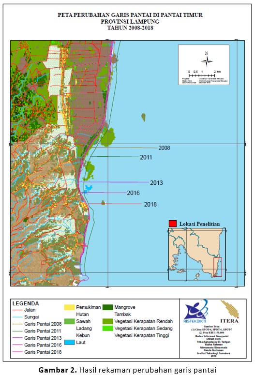
The erosion and sedimentation process that occurred in the east coast of South Lampung is a natural process affecting the balance of coastal sediment transport and resulting in the instability of coastal lines to the loss of the coastal communities along the coast, such as silting the river and can disturb the traffic of fishing boats. This is seen as a natural process influenced by the magnitude of wave energy coming, the type and size of sediment deposited, and coastal morphology. This research aims to analyze sediment and its effect on the changing coastline. The calculation approach with the empirical formula against coastal sediment data and wave data is used to predict the natural processes occurring along the coast. Analysis of SPOT 6/7 satellite imagery years 2008, 2013, 2016, and 2018 is the next step to estimate the similarity with empirical calculation results. The results showed that the East Coast had a characteristic mud sediment size ranging from 0.0258 – 0033 mm with the highest wave from the east with a wave height above 2.57 m and a period above 8,015 S. Research locations tend to undergo sedimentation processes that are influenced by waves, grain size, and there are rivers carrying sediments and deposits in the river estuary.
Downloads
References
[2] Sulaiman, D., Bangunan Pengendali Erosi Pantai Berlumpur. CV Budi Utama. Yogyakarta, 2018.
[3] Triatmodjo, B., Teknik Pantai. Beta Offset. Yogyakarta, 1999.
[4] Halim., Halili., dan La Ode A., “Studi Perubahan Garis Pantai dengan Pendekatan Penginderaan Jauh di Wilayah Pesisir Kecamatan Soropi,†Sapa Laut, vol. 1, p.24-31, 2016.
[5] Bengen., DG., Pengenalan dan Pengelolaan Ekosistem Mangrove. Pusat Kajian Sumberdaya Pesisir dan Lautan-IPB. Bogor, 2000.
[6] Sorensen, R. M., Basic Coastal Engineering. John Wiley & Sons. New York, 1991.
[7] Shiyoma, S., “Calculation of Longshore Currentsand Associted Littoral Drift.†In Dronkers and Scheffers (eds.) Physics of Esturies and Coastal Seas. A. A. Balkema, Rotterdam, 1998, p.163-167
[8] Goda, Y., “Revisting Wilson’s Formula for Simplified Wind-Wave Prediction,†Journal of Waterway, Port, Coastal and Ocean Engineering ASCE, vol. 129, p. 93-95, 2003.
[9] Coastal Engineerig Research Center (CERC). Shore Protection Manual, vols I to III. US Army Corps of Engineers, Coastal Engineering Research Centre, US Govt Printing Office, 1984.
[10] Kraus, N.C., Larson, M., dan Kreibel, D.L. Evaluation of beach erosion and accretion predictors. Proc. Coastal Sediments ’91, ASCE, 572-587, 1991.
[11] Danoedoro, P., Pengolahan Citra Digital dan Aplikasinya dalam Bidang Penginderaan Jauh. Fakultas Geografi Universitas Gajah Mada, 1996.
[12] Pariwono, J. I., Kondisi Oseanografi Perairan Pesisir Lampung. Laporan Teknis Penyusunan Atlas Sumberdaya Wilayah Pesisir Lampung, 1999.

This work is licensed under a Creative Commons Attribution-NonCommercial 4.0 International License.

All the content on Journal of Science and Applicative Technology (JSAT) may be used under the terms of the Creative Commons Attribution-NonCommercial 4.0 International License.
You are free to:
- Share - copy and redistribute the material in any medium or format
- Adapt - remix, transform, and build upon the material
Under the following terms:
- Attribution - You must give appropriate credit, provide a link to the license, and indicate if changes were made. You may do so in any reasonable manner, but not in any way that suggests the licensor endorses you or your use.
- NonCommercial - You may not use the material for commercial purposes.
- No additional restrictions - You may not apply legal terms or technological measures that legally restrict others from doing anything the license permits.


